

Topographical Surveying for UK Infrastructure Projects: A 2026 Technical Case Study
- John Palmer (Director, DTA)

- Jun 10
- 12 min read
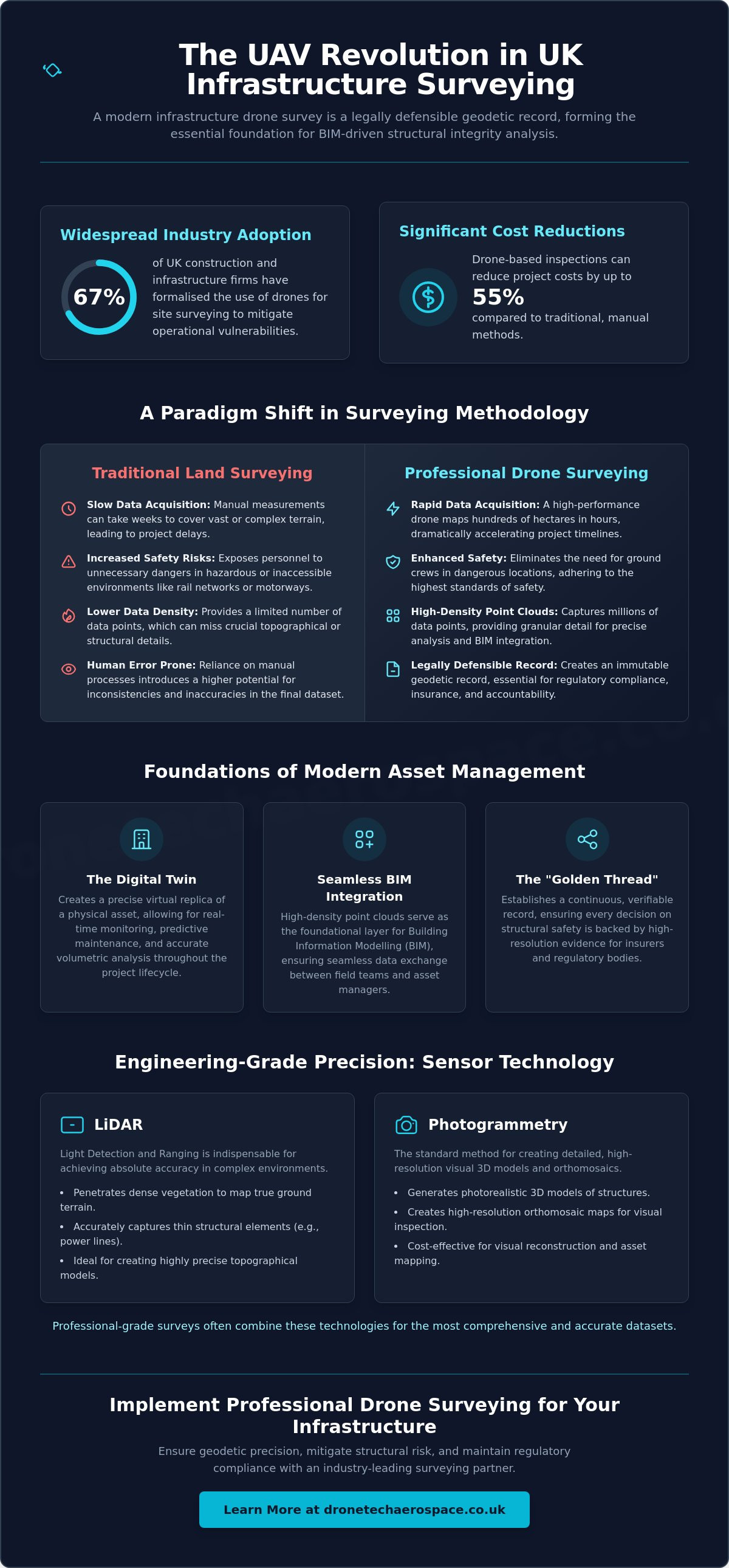
For modern UK infrastructure, an infrastructure drone survey is no longer merely an aerial photograph; it is a legally defensible geodetic record that serves as the essential foundation for BIM-driven structural integrity. You recognise that traditional land surveying methods often incur prohibitive costs and expose personnel to unnecessary safety risks, particularly in hazardous or inaccessible environments. Recent industry data from HireDronePilot indicates that 67 per cent of UK construction companies have now integrated UAV technology into their surveying workflows to mitigate these specific operational vulnerabilities and reduce inspection costs by up to 55 per cent.
This technical case study demonstrates how professional-grade UAV data collection ensures absolute geodetic precision whilst significantly reducing project timelines through rapid data acquisition. By reading this analysis, you will discover the methodology required to generate high-density point clouds for seamless BIM integration and verifiable structural integrity reports, which are essential for insurance and regulatory compliance. We will examine the practical application of the January 2026 CAA regulatory framework, the strategic use of LiDAR and photogrammetry, and the elimination of data silos between field teams and asset managers.
Key Takeaways
Understand the technical distinctions between LiDAR and photogrammetry to ensure millimetre-level geodetic precision for complex asset mapping.
Learn how a professional infrastructure drone survey provides an immutable audit trail for insurance risk assessments and verifiable structural integrity reports.
Discover the operational framework for executing multi-hectare topographical surveys whilst maintaining strict CAA compliance in restricted UK airspace.
Identify methods for integrating high-density point clouds into BIM workflows to facilitate seamless data exchange between survey teams and asset managers.
Evaluate the essential criteria for selecting a high-capacity surveying partner based on advanced data processing capabilities and a proven industrial track record.
Table of Contents
Modernising UK Infrastructure: The Strategic Shift to UAV-Led Aerial Surveys
Engineering-Grade Precision: Navigating LiDAR and Photogrammetry for Complex Assets
Optimising Civil Engineering Workflows: A Case Study in Large-Scale Topographical Mapping
Mitigating Structural Risk: Ensuring Compliance and Insurance Accountability via Aerial Inspection
Implementing Professional Drone Surveying: Your Framework for Infrastructure Integrity
Modernising UK Infrastructure: The Strategic Shift to UAV-Led Aerial Surveys
A professional infrastructure drone survey represents a sophisticated geodetic data collection method that has replaced traditional terrestrial methods for large-scale UK projects. This process involves the deployment of high-specification Unmanned Aerial Vehicles (UAVs) equipped with advanced sensors to capture spatial data with absolute geodetic precision. It's not merely about capturing imagery; it's about establishing a rigorous, measurable framework that serves as the primary source of truth for civil engineers and project stakeholders.
The transition from traditional land surveying, which relies on manual total station measurements, to rapid aerial data acquisition represents a fundamental shift in civil engineering methodology. By utilising advanced aerial survey techniques, survey teams can now map hundreds of hectares in a fraction of the time required by ground-based crews. This evolution is driven by the need for higher data density and the requirement to eliminate human error in hazardous environments. Modern infrastructure projects in the UK now mandate UAV integration because the resulting datasets provide a level of granular detail that traditional methods simply cannot match.
According to 2026 industry reports from HireDronePilot, 67 per cent of UK construction and infrastructure firms have now formalised the use of drones for site surveying. This widespread adoption is underpinned by the ability to create a "Digital Twin" of the asset. This virtual replica allows for real-time monitoring, predictive maintenance, and precise volumetric analysis. By establishing an infrastructure drone survey as the baseline, project managers can track every centimetre of progress against the original design specifications with total professional accountability.
The Necessity of High-Performance Aerial Data
UAVs effectively overcome the inherent limitations of manual surveys on vast or complex sites such as rail networks, motorway expansions, and energy plants. Where a manual team might take weeks to traverse difficult terrain, a high-performance drone completes the task in hours. This shift towards data-driven decision-making allows UK civil engineering firms to identify potential structural issues or topographical discrepancies before they escalate into costly delays. In national-scale projects, the precision of this data is not just a preference; it's a requirement for maintaining the high standards of safety and efficiency expected in the current regulatory environment.
BIM Integration and the Golden Thread of Information
The integration of drone survey data for BIM provides the foundational layer for the entire project lifecycle. This data supports the concept of the "Golden Thread" of information, ensuring that every decision regarding structural safety is backed by verifiable, high-resolution evidence. By maintaining this continuous record, asset managers can demonstrate compliance and structural integrity to insurers and regulatory bodies. High-resolution orthomosaic mapping provides a continuous, measurable visual record that ensures long-term asset integrity through every phase of the project lifecycle.
Engineering-Grade Precision: Navigating LiDAR and Photogrammetry for Complex Assets
Achieving geodetic precision in an infrastructure drone survey requires a nuanced understanding of sensor technology. Whilst photogrammetry is the standard for high-resolution visual reconstruction, Light Detection and Ranging (LiDAR) is indispensable for mapping terrain beneath dense vegetation or capturing thin structural elements like power lines. Professional-grade surveys often combine these technologies to produce a comprehensive dataset that meets the rigorous standards of civil engineering and industrial asset management.
LiDAR: Penetrating Canopies and Complex Voids
LiDAR sensors emit active laser pulses that can penetrate foliage to reach the ground surface. This makes them the preferred choice for topographical land surveys in overgrown UK environments where traditional photogrammetry would only capture the top of the canopy. This technology is particularly effective for high-value industrial assets where precise structural geometry is required without the interference of shadows or low-contrast surfaces. Once the raw data is captured, it undergoes a methodical processing workflow to filter out non-ground points. This results in actionable LAS files that define the site's true topography with absolute clarity, providing a reliable foundation for civil engineering design.
Photogrammetry: High-Resolution Visual Documentation
Photogrammetry excels when sub-centimetre Ground Sample Distance (GSD) is necessary for roof and building inspections. By overlapping high-resolution images, we create 3D measured building models that allow engineers to inspect defects with microscopic detail. These orthomosaic maps provide a continuous visual record for construction site monitoring. This ensures every phase of the project is documented for compliance and insurance purposes, creating a high-fidelity visual audit trail that complements the geodetic data.
Geodetic accuracy is maintained through the strategic placement of Ground Control Points (GCPs). These anchor the aerial data to known coordinates on the Earth's surface, ensuring millimetre-level precision. This is critical when integrating survey data into BIM environments to avoid spatial discrepancies. Selecting the appropriate sensor is vital for specialised requirements; thermal sensors identify heat loss or electrical faults, whilst specialised payloads are used for Drone Fugitive Methane Gas Surveys to detect leaks in industrial pipelines. Compliance with the latest Civil Aviation Authority rules ensures these complex operations are conducted within a safe and legal framework, providing the professional accountability required for national infrastructure.
Optimising Civil Engineering Workflows: A Case Study in Large-Scale Topographical Mapping
Executing a multi-hectare infrastructure drone survey on a national site requires a methodical framework that prioritises geodetic integrity and operational safety. Unlike smaller commercial applications, large-scale infrastructure projects demand a rigorous pre-flight planning phase that accounts for complex UK airspace and the specific constraints of hazardous industrial environments. This section outlines the professional workflow required to deliver engineering-grade data for civil engineering stakeholders.
Phase 1: Mobilisation and Geodetic Control
The mobilisation phase establishes the geodetic foundation of the entire project. We utilise a combination of Real-Time Kinematic (RTK) and Post-Processed Kinematic (PPK) technologies to ensure that every data point is accurately georeferenced. Whilst onboard GNSS systems provide high levels of precision, the deployment of physical Ground Control Points (GCPs) remains a non-negotiable requirement for verifying geodetic consistency across vast distances. This dual-layer approach ensures that the resulting datasets align perfectly with existing CAD and BIM environments. Professional accountability is further reinforced through site-specific risk assessments (RAMS), which are tailored to the unique hazards of the industrial environment, including:
Identification of electromagnetic interference sources that could affect UAV telemetry.
Coordination with National Air Traffic Services (NATS) for operations within restricted flight zones.
Integration of ground-based safety protocols to protect personnel in active construction areas.
Management of environmental variables, such as wind shear and precipitation, that impact data quality.
Phase 2: Technical Execution and Data Processing
Technical execution involves the deployment of automated flight paths designed to capture exhaustive data of both vertical and horizontal assets. We balance coverage area with the required point cloud density to ensure that the final deliverables provide the necessary resolution for structural analysis. For projects involving bulk material management, we implement a rigorous Quality Control (QC) process to verify the accuracy of Drone Stockpile Volume Surveys, ensuring that volumetric calculations are within established engineering tolerances. This transition from raw aerial imagery to a 3D measured building survey allows for the precise documentation of complex structural geometries.
Deployment of nadir flight patterns for horizontal topographical mapping.
Utilisation of oblique imagery for the reconstruction of vertical facades and structural voids.
Automated overlap synchronisation to ensure high-density tie-point generation.
Batch processing of raw data into BIM-ready formats (such as .IFC or .RVZ).
The final deliverables are structured to integrate seamlessly into existing engineering workflows. By providing CAD-ready contours and high-resolution digital surface models (DSM), we enable project managers to conduct precise site analysis without the delays associated with manual data conversion. This systematic approach ensures that the infrastructure drone survey serves as a reliable, long-term asset for the project lifecycle.
Mitigating Structural Risk: Ensuring Compliance and Insurance Accountability via Aerial Inspection
The integration of an infrastructure drone survey into risk management protocols provides an immutable audit trail that traditional methods cannot replicate. For corporate and industrial clients, this data serves as the definitive record for insurance risk assessments and compliance audits. By capturing high-resolution, georeferenced evidence of asset condition, organisations can demonstrate a rigorous approach to maintenance; this is often a prerequisite for securing favourable insurance premiums in high-stakes sectors. It's not just about safety; it's about establishing a legally defensible record that satisfies both internal safety boards and external regulatory bodies.
Specialised sensors allow for the detection of invisible threats that manual inspections often miss. We execute Drone Fugitive Methane Gas Surveys to pinpoint leaks in industrial pipelines and storage facilities with absolute precision. Whilst traditional inspections rely on visual cues, these surveys provide the technical evidence required for insurance loss adjusting and post-incident structural analysis. This level of granular detail ensures that any potential for catastrophic asset failure is identified and mitigated well before it impacts operational continuity.
Industrial Integrity and Preventative Maintenance
Thermal surveys identify hotspots in electrical infrastructure and renewable energy assets. By conducting regular drone building inspections, facility managers transition from reactive repairs to a proactive maintenance model. This shift is vital amongst UK industrial facilities where downtime's costly. High-resolution thermographic imagery reveals hidden defects in insulation, allowing for targeted interventions that preserve structural integrity.
Confined Spaces and Hazardous Environments
The safety ROI of employing internal and confined space inspections (ball/cage-drone) is undeniable. These specialised UAVs operate within boilers and storage tanks, eliminating the need for expensive scaffolding or high-risk manual entry. By removing personnel from hazardous environments, organisations reduce liability exposure. These drones capture high-resolution visual data in zero-light, providing views of internal welds previously considered inaccessible.
In the event of an unforeseen incident, a pre-existing infrastructure drone survey provides a vital baseline for structural analysis. This historical record allows loss adjusters to compare verified asset conditions with post-incident data, accelerating the claims process and ensuring professional accountability. Ultimately, the use of professional-grade UAVs creates a safer, more transparent environment for both asset owners and their insurers.
Implementing Professional Drone Surveying: Your Framework for Infrastructure Integrity
Selecting a partner for a national-scale infrastructure drone survey requires more than an evaluation of hardware. It demands a provider with a proven 10-year track record in UK industrial surveying. Technical prowess extends beyond the flight itself; it resides in the sophisticated data processing workflows that transform raw points into geodetic models. National coverage and rapid deployment capabilities are essential for maintaining project momentum, especially when unexpected structural concerns arise on remote or hazardous sites. A high-performance partner operates as an extension of your engineering team, providing the technical assurance required for high-stakes decision-making.
The Drone Tech Aerospace Distinction
Our firm provides a high-capacity solution for corporate clients who require absolute precision and professional accountability. We maintain specialised expertise in Drone Fugitive Methane Gas Surveys and Internal & Confined Space Inspections using ball-drone technology. This allows us to operate in environments where standard UAVs cannot function. Our service breadth is exhaustive, encompassing everything from Drone Stockpile Volume Surveys to intricate 3D modelling and Measured Building Surveys. This commitment to formal, professional-grade delivery ensures that every dataset meets the rigorous standards of the heavy industry and civil engineering sectors.
Securing Your Infrastructure Asset Data
Moving from a site-specific requirement to a high-precision topographical model involves a structured engagement process. We provide bespoke technical proposals that align with your project geodetic requirements and internal safety protocols. Consulting on sensor selection is a critical step in this framework. We ensure the chosen payload, whether LiDAR, thermal, or high-resolution RGB, meets the specific data density needs of your BIM manager. This methodical approach guarantees that the resulting information is both actionable and compliant with current UK standards. To begin this process, Contact Drone Tech Aerospace for a professional infrastructure survey consultation and secure the geodetic integrity of your next project.
Securing the Future of UK Infrastructure Through Geodetic Precision
The transition towards UAV-led data collection marks a permanent shift in how national assets are managed. By integrating high-precision LiDAR and photogrammetry into standard civil engineering workflows, project managers ensure that every millimetre of a site is accounted for within a BIM-ready environment. Implementing a comprehensive infrastructure drone survey establishes a geodetic foundation that supports the entire lifecycle of an asset; this ranges from initial topographical mapping to long-term structural integrity monitoring and insurance accountability.
Reliability in these high-stakes environments is non-negotiable. Our firm provides over 10 years of operational excellence in UK aerial surveying, delivering the technical expertise required for the most demanding industrial projects. This includes the deployment of specialist ball/cage-drone technology for hazardous confined space inspections and the generation of high-density point clouds for engineering-grade BIM data. Ensure your project meets the highest standards of professional accountability and geodetic accuracy. Request a technical consultation for your national infrastructure project today. We look forward to establishing a high-performance partnership for your next large-scale development.
Frequently Asked Questions
How accurate is an infrastructure drone survey compared to traditional methods?
An infrastructure drone survey provides geodetic precision comparable to traditional terrestrial methods, often achieving millimetre-level accuracy across vast sites. This is achieved through the integration of Real-Time Kinematic (RTK) technology and the strategic placement of physical Ground Control Points (GCPs). Whilst traditional total station surveys are limited by the speed of manual measurements, aerial acquisition captures millions of data points in a fraction of the time, ensuring a higher density of information for civil engineering analysis.
What are the main benefits of using LiDAR for UK infrastructure projects?
The primary benefit of LiDAR for UK infrastructure is its ability to penetrate dense vegetation to record the true ground surface, which is critical for topographical land surveys in overgrown areas. Unlike photogrammetry, LiDAR is an active sensor that captures precise structural detail of high-value industrial assets, including power lines and complex pipework. This technology ensures that even the most intricate geometries are documented with absolute clarity, providing a reliable foundation for engineering design.
How does drone data integrate with existing BIM and CAD software?
Drone-derived datasets integrate seamlessly with BIM and CAD software through the export of industry-standard file formats such as .IFC, .RVZ, and .DXF. These high-density point clouds and orthomosaic maps provide a precise geodetic baseline for project lifecycle management. By establishing this "Digital Twin," engineering teams can conduct accurate spatial analysis and clash detection within their existing software environments, ensuring that the aerial data serves as a functional tool for design and construction.
What safety regulations must be followed for drone surveys on industrial sites?
Operators must adhere to the latest Civil Aviation Authority (CAA) framework, which mandates the use of UK class-marked aircraft and the broadcasting of Remote ID data. Professional pilots must hold a General Visual Line of Sight Certificate (GVC) as the minimum standard for industrial operations. On-site, rigorous Risk Assessments and Method Statements (RAMS) are required to manage specific hazards, such as electromagnetic interference or the presence of non-involved personnel in active construction zones.
Can drones be used for internal inspections of confined infrastructure spaces?
Specialised internal and confined space inspections (ball/cage-drone) are routinely used to survey chimneys, storage tanks, and culverts without requiring manual entry. These protective frames allow the UAV to navigate high-pressure or zero-light environments whilst capturing high-resolution visual evidence of structural welds and defects. This methodology significantly reduces liability exposure by removing personnel from hazardous spaces, providing a safer and more efficient alternative to traditional scaffolding or rope-access inspections.
How long does it take to process topographical data from a large-scale drone survey?
The timeline for processing topographical data typically ranges from 24 to 72 hours, depending on the scale of the site and the required point cloud density. Large-scale infrastructure projects involving hundreds of hectares require significant computational power to convert raw aerial imagery or LiDAR pulses into actionable geodetic models. Once the initial processing is complete, the data undergoes a rigorous quality control phase to verify accuracy against established ground control before the final engineering-ready files are delivered.
What is the cost-benefit analysis of using UAVs for stockpile volume calculations?
The cost-benefit analysis of using UAVs for stockpile volume calculations reveals a significant reduction in operational risk and survey duration compared to manual methods. Aerial surveys eliminate the need for personnel to climb hazardous material piles, whilst providing volumetric accuracy within a 1 to 2 per cent margin of error. This rapid data acquisition allows for more frequent inventory audits, providing facility managers with real-time insights into material levels without disrupting on-site machinery or production schedules.
How do drone surveys support insurance risk assessments for high-value assets?
Professional drone surveys provide an immutable visual and geodetic audit trail of an asset's condition, serving as primary evidence for insurance risk assessments. This technical documentation is essential for loss adjusters and risk managers when evaluating high-value infrastructure. By utilising specialised sensors for fugitive gas detection or thermal anomalies, organisations can identify potential failures before they escalate into catastrophic incidents. This proactive approach to asset integrity is often a key requirement for securing comprehensive insurance coverage in industrial sectors.


Comments