
Drone Methane Detection and Surveying : A Technical Guide for Industrial Emissions Monitoring
- John Palmer (Director, DTA)

- Jun 6
- 12 min read
The energy sector accounts for approximately 40% of global methane emissions from human activity, yet traditional ground-based detection methods frequently fail to capture the full scale of these fugitive losses. For industrial operators, the challenge lies in moving beyond simple detection to a rigorous, defensible methodology for aerial methane quantification that satisfies both regulatory bodies and ESG stakeholders. Inaccurate emission reporting represents a significant financial risk, particularly as the industry shifts towards the scaled deployment of integrated monitoring systems.
This technical guide explains how advanced UAV-based gas sensing converts intermittent fugitive leak data into actionable, high-precision mass flow measurements (specifically kg/hr flow rates). By utilising professional-grade mid-infrared analysers, such as the Aeris Technologies MIRA Strato LDS, operators can calculate precise emission volumes whilst significantly reducing site downtime during inspections. We examine the deployment of these specialised drone fugitive methane gas surveys, the technical integration of mid-IR sensor technology, and the protocols for generating the defensible data required for 2026 reporting deadlines.
In 2019, DTA was the second drone company in the world to develop an operational and proven drone for drone methane detection and surveying and so we are uniquely positioned to help in this process.
Key Takeaways for Drone Methane Detection and Surveying
Understand the transition from qualitative visual detection to precise aerial methane quantification, enabling the calculation of specific mass flow rates in kg/hr for rigorous regulatory compliance.
Learn the technical mechanics of Tuneable Diode Laser Absorption Spectroscopy (TDLAS) and how path-integrated concentration data ensures high-resolution accuracy in complex industrial environments.
Evaluate the operational advantages of remote aerial surveys over traditional ground-based methods, including enhanced personnel safety and the ability to monitor vast infrastructure without site downtime.
Identify critical environmental parameters and flight path strategies, such as cross-wind transects and source boxing, required to maintain data integrity during fugitive emission audits.
Discover the requirements for defensible industrial reporting, including the use of georeferenced flux maps to pinpoint and prioritise maintenance across large-scale assets.
Table of Contents
Beyond Detection: The Critical Role of Aerial Methane Quantification
The Science of Precision: How UAV Sensors Calculate Mass Flow Rates
Evaluating Methodology: Aerial Remote Sensing vs. Traditional Ground-Based Sniffing
Operational Parameters for Accurate Fugitive Emission Surveys
Implementing High-Resolution Methane Audits with Drone Tech Aerospace
Beyond Detection: The Critical Role of Aerial Methane Quantification
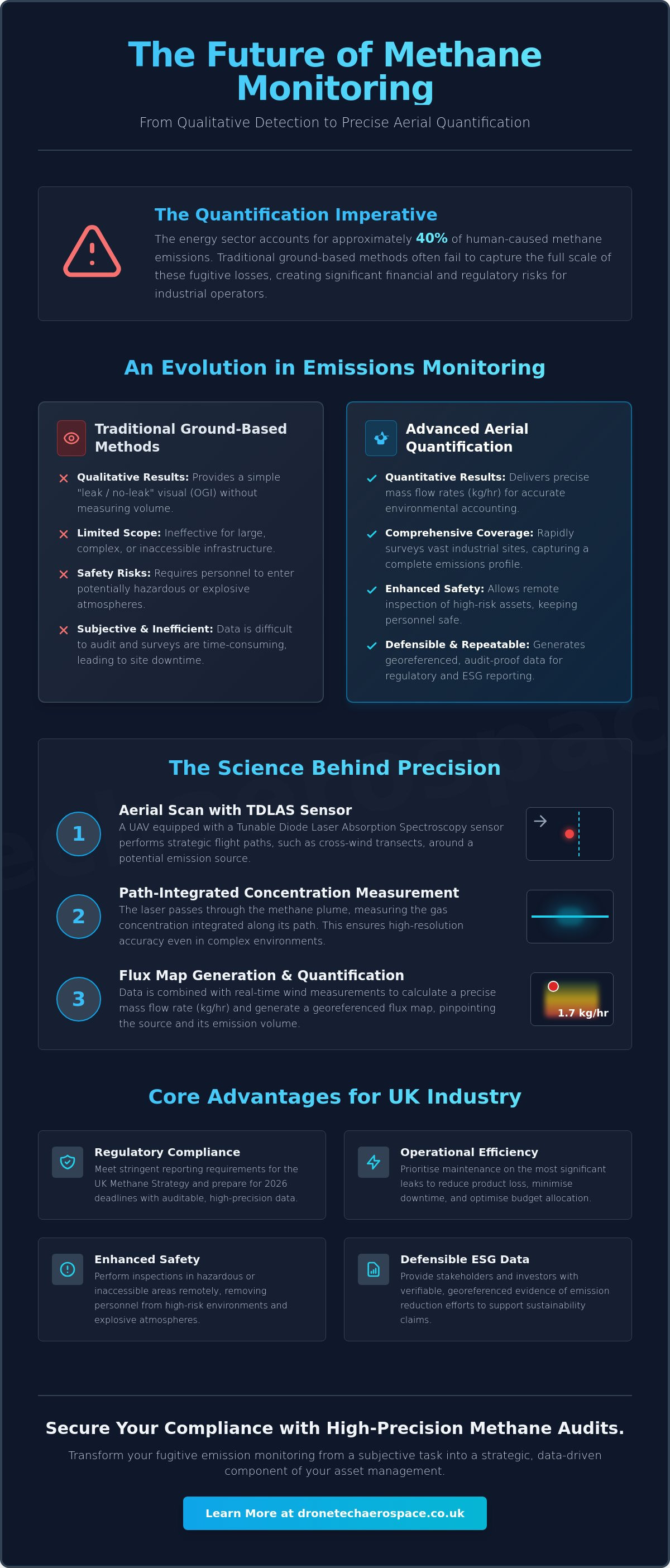
Aerial methane quantification represents a sophisticated advancement in industrial emissions monitoring, moving beyond simple identification to the precise measurement of mass flow rates. This process utilises UAV-mounted sensors to calculate the volume of methane being released into the atmosphere, typically expressed in kilograms per hour (kg/hr) or grams per second (g/s). Whilst traditional methods focused on locating leaks, modern industrial standards require the rigorous quantification of fugitive emissions to satisfy environmental, social, and governance (ESG) reporting mandates. This transition is fundamental for operators who must now provide defensible data to support corporate sustainability claims and regulatory filings.
The Evolution from OGI to Quantitative Measurement
For many years, Optical Gas Imaging (OGI) served as the primary tool for leak detection and repair (LDAR) programmes. These specialised thermal cameras identify methane plumes visually, allowing technicians to locate the source of a leak quickly. However, OGI is inherently qualitative; it confirms the presence of a gas but cannot determine the magnitude of the release. A small, visually dramatic plume might represent a lower mass flow than a high-pressure, invisible leak elsewhere. Modern asset management requires more than a "leak-no-leak" binary. By integrating greenhouse gas monitoring methods with drone technology, operators gain the ability to prioritise repairs based on the actual environmental impact and financial loss associated with each source. This data-driven approach ensures that maintenance budgets are allocated to the most significant emitters first.
Why Quantification is Essential for UK Industry
The UK's commitment to achieving Net Zero by 2050, alongside interim targets to reduce methane emissions by 30% by 2030, has placed industrial operators under intense scrutiny. Precise drone methane detection and surveying is no longer optional for those managing vast infrastructure, such as natural gas terminals, anaerobic digestion plants, or landfill sites. It provides the high-precision data needed to reduce "lost and unaccounted for" (LAUF) gas, which directly impacts a utility provider's bottom line. The benefits of this quantitative approach include:
Regulatory Compliance: Meeting the stringent reporting requirements of the UK Methane Strategy and Environment Agency standards.
Operational Efficiency: Reducing product loss by identifying high-volume leaks that traditional sniffing might underestimate.
Enhanced Safety: Performing remote quantification in hazardous or inaccessible environments without placing personnel in potentially explosive atmospheres.
Defensible ESG Data: Providing stakeholders with verifiable, georeferenced evidence of emission reductions.
Remote quantification ensures that inspections are completed with absolute professional accountability. It removes the subjectivity of manual ground-based surveys and replaces it with a repeatable, scientific methodology that stands up to third-party audits. This methodology transforms fugitive emission detection into a core component of preventative maintenance and environmental accounting.

The Science of Precision: How UAV Sensors Calculate Mass Flow Rates
Precision in drone methane detection and surveying relies on the technical synergy between advanced spectroscopy and real-time meteorological data. It's not sufficient to merely detect a plume; the system must interpret the plume's movement and density within a three-dimensional spatial framework. This requires a sophisticated payload that integrates spectroscopic sensors with high-frequency anemometry and precise positioning systems to deliver defensible mass flow data.
Tuneable Diode Laser Absorption Spectroscopy (TDLAS) Explained
The core of quantitative aerial sensing is Tuneable Diode Laser Absorption Spectroscopy (TDLAS). This technology operates by emitting a laser at a specific wavelength that matches the absorption line of methane molecules. As the laser light passes through a gas plume, the intensity of the light decreases in direct proportion to the methane concentration. A significant advantage of TDLAS is its immunity to cross-interference from other hydrocarbons or water vapour, which frequently plague less sophisticated sensors. This specificity ensures that the data remains accurate even in the humid or chemically complex environments typical of UK industrial sites.
High-resolution TDLAS sensors achieve sensitivity thresholds in the parts-per-billion (ppb) range, enabling the detection of even minor fugitive leaks. The importance of this sensitivity was highlighted in the California Methane Survey, where aerial remote sensing identified that a small fraction of point sources were responsible for a significant portion of total emissions. Such findings underscore the necessity of using industrial-grade payloads for effective environmental accounting.
From Concentration to Flux: The Role of Wind Data
Converting raw concentration readings into an actionable mass flow rate requires the integration of real-time wind speed and direction data. The sensor measures path-integrated concentration, expressed in ppm-m (parts per million-metres), which represents the total amount of methane encountered along the laser's path. To translate this into a kg/hr flow rate, mathematical modelling applies the wind vector to the concentration data. Mass flux is the rate of gas flow through a specific area over time. By calculating this flux across a defined boundary, the system determines the total emission rate from the source.
Spatial accuracy is guaranteed by synchronising the sensor data with high-precision GPS and Inertial Measurement Unit (IMU) readings. These components ensure every measurement is georeferenced with absolute precision, allowing operators to attribute emissions to specific assets such as valves or storage tank seals. For companies seeking this level of technical detail, commissioning professional drone fugitive methane gas surveys ensures that all data is both accurate and actionable for maintenance teams.
Evaluating Methodology: Aerial Remote Sensing vs. Traditional Ground-Based Sniffing
Traditional Leak Detection and Repair (LDAR) programmes have historically relied on manual "sniffing" techniques using handheld Toxic Vapour Analysers (TVA) or Flame Ionisation Detectors (FID). Whilst these tools provide high sensitivity at the point of contact, they're fundamentally limited by the physical reach and speed of the technician. In contrast, drone methane detection and surveying allows for the rapid assessment of vast industrial complexes, identifying super-emitters that ground teams might miss due to the sheer scale of the infrastructure. This shift in methodology represents a move from slow, point-by-point inspection to a holistic, system-wide monitoring strategy that aligns with modern industrial requirements.
LDAR Efficiency: UAV vs. Manual Inspection
The operational disparity between drone-based surveys and manual inspections is significant. A ground team might take several days to inspect a large processing facility or a complex network of pipelines. A UAV can cover the same area in a fraction of the time, often assessing hundreds of hectares per day with absolute precision. Drones provide immediate access to high-elevation assets, such as flare stacks, vents, and roof-mounted valves, which would otherwise require expensive scaffolding or specialized rope access teams. Because these surveys are non-intrusive, they don't require site shutdowns or complex hot-work permits, ensuring that production remains uninterrupted whilst critical environmental data is gathered.
Safety and Technical Accuracy Trade-offs
Safety remains a primary driver for adopting remote sensing in heavy industry. Manual LDAR requires personnel to enter potentially explosive atmospheres (ATEX zones) to obtain accurate readings. Aerial methods remove this risk entirely by maintaining a safe standoff distance from the source. Technically, point sensors only measure the concentration at a specific coordinate, which is problematic for intermittent or shifting plumes. Peer-reviewed research into the use of UAS for direct quantification of methane demonstrates that path-integrated sensors are far more effective at capturing the total flux of a plume. They measure the gas density across a wider cross-section rather than a single point, providing a more reliable foundation for mass flow calculations.
Data Defensibility and Audit Trails
Modern industrial compliance demands more than a simple tick-box exercise. Manual logs are prone to human error and often lack the spatial context required for complex environmental audits. UAV surveys generate a comprehensive digital audit trail where every measurement is georeferenced and timestamped. This data can be overlaid onto high-resolution orthomosaics, providing a visual map of leak locations amongst complex pipework. This level of detail simplifies the prioritisation of repair schedules, allowing EHS managers to focus on the highest-impact leaks first. It's a professional-grade solution that transforms raw sensor data into a defensible record for ESG reporting and regulatory scrutiny.
Operational Parameters for Accurate Fugitive Emission Surveys
Achieving high-precision results in drone methane detection and surveying requires more than advanced sensors; it demands a rigorous operational protocol. Environmental variables and flight dynamics directly influence the signal-to-noise ratio of the collected data. Professional surveys must be conducted within specific "wind windows" to ensure that the methane plume remains stable and measurable. Failure to adhere to these parameters can result in significant measurement uncertainty, undermining the defensibility of the final report.
Environmental Constraints and Wind Windows
The ideal wind speed for accurate quantification typically ranges between 2 and 10 metres per second (m/s). Speeds below this threshold often lead to stagnant or unpredictable plume behaviour, whilst speeds above it can disperse the gas too rapidly for precise concentration measurement. Atmospheric stability also plays a critical role in data integrity. Surveyors prefer neutral or slightly unstable conditions to prevent the plume from "grounding" or lofting beyond the sensor's reach. Additionally, sophisticated processing algorithms must filter out background methane levels (the ambient concentration) to ensure the reported flow rates reflect only the fugitive emissions from the target asset. This process, often referred to as determining the "colour" of the data, is essential for isolating specific leak sources within complex industrial clusters.
Flight Patterns and Data Acquisition Strategy
Systematic data acquisition involves intercepting the plume at multiple points to build a comprehensive three-dimensional model of the emission. Operators frequently utilise "box" or "L-shaped" flight patterns, which involve flying perpendicular to the wind direction downwind of the source. Multiple transects at varying altitudes are required to capture the full vertical extent of a plume. Repeat passes are essential to reduce statistical uncertainty and improve the confidence intervals of the final mass flow calculation. Before any flight, a comprehensive pre-flight site assessment is conducted to identify potential interference sources, such as nearby exhaust vents or complex topography that might disrupt airflow and complicate the flux calculation.
Sensor altitude and flight speed are carefully calibrated to maximise the signal-to-noise ratio. Flying too high increases the distance from the source, potentially diluting the signal, whilst excessive speed can lead to spatial smearing of the data. Maintaining a steady, low-altitude flight path ensures the sensor captures the highest possible resolution of the methane flux. For asset managers requiring this level of technical rigour, commissioning professional Drone Fugitive Methane Gas Surveys provides the necessary expertise to navigate these operational complexities and deliver actionable results.
Implementing High-Resolution Methane Audits with Drone Tech Aerospace
Drone Tech Aerospace delivers a sophisticated framework for drone methane detection and surveying, engineered specifically for high-stakes industrial environments. We operate as a high-performance partner, providing the technical prowess required to manage complex, large-scale emissions monitoring with absolute precision. Our methodology prioritises professional accountability, ensuring that every survey yields actionable intelligence for industrial asset management. We understand the nuances of the UK regulatory landscape and the necessity of providing defensible data for corporate stakeholders and environmental audits.
Bespoke Technical Reporting for ESG Compliance
Our reporting standards exceed basic detection logs by providing georeferenced flux maps that pinpoint exact emission sources with centimetre-level accuracy. Each report provides granular data points, including specific source coordinates, calculated mass flow rates (kg/hr), and rigorous uncertainty estimates. These outputs are structured to satisfy the stringent requirements of UK environmental regulators and professional insurance adjusters. By delivering clear, high-resolution data, we enable EHS managers to implement effective maintenance prioritisation based on actual environmental impact and financial risk. This level of detail is fundamental for accurate ESG reporting and the verification of corporate carbon reduction targets.
For industrial operators who require further independent assurance, The Testing Lab PLC offers accredited laboratory services that ensure every technical aspect of site compliance is verified by a third-party specialist.
The High-Performance Partner Advantage
The efficacy of our audits stems from the use of professional-grade sensors and proprietary data processing workflows that filter out ambient interference. We frequently integrate methane concentration data with high-resolution 3D measured building models to provide a comprehensive spatial context for every leak. This allows for the precise visualisation of gas plumes amongst complex pipework and high-elevation vents. Drone Tech Aerospace brings a decade of operational history to every project, offering a reliable, UK-wide service for large-scale industrial sites, including natural gas terminals and anaerobic digestion plants. Our pilots undergo rigorous training to operate safely within hazardous environments, maintaining a safety-first culture that respects the operational constraints of live industrial sites.
We offer a comprehensive solution that transforms raw sensor data into a strategic asset for industrial compliance.
Contact our technical team to organise your next methane survey and ensure your facility meets the highest standards of environmental and operational accuracy.
Securing Operational Accountability with High-Precision Aerial Audits
Industrial operators must transition from simple leak detection to a rigorous framework of drone methane detection and surveying to meet 2030 reduction targets. This methodology replaces qualitative observations with high-precision mass flow data (specifically kg/hr flow rates), allowing for the accurate calculation of emissions across vast infrastructure. By integrating TDLAS technology with precise meteorological modelling, facilities can prioritise repairs based on actual environmental impact and financial risk. This data-driven approach ensures that environmental, social, and governance (ESG) reporting remains robust and defensible under regulatory scrutiny.
Drone Tech Aerospace provides the sophisticated expertise required for these high-stakes inspections. With 10 years of industrial aerial surveying experience and specialised technical payloads (including TDLAS and thermal sensors), we deliver national UK coverage for large-scale infrastructure projects. Our georeferenced flux maps ensure your compliance data is both accurate and actionable.
Request a technical proposal for your aerial methane survey to secure your facility's operational integrity and environmental leadership.
Frequently Asked Questions
How accurate is aerial methane quantification compared to ground-based sensors?
Aerial systems provide superior accuracy for determining total mass flow rates (kg/hr) by capturing the entire flux of a plume rather than single-point concentrations. Whilst ground-based sensors offer high sensitivity at the point of contact, they often miss the broader vertical extent of a leak. Professional drone methane detection and surveying utilises path-integrated concentration data to ensure that the total volume of gas escaping into the atmosphere is captured and calculated with high statistical confidence.
Can drones detect and quantify methane leaks in high wind conditions?
Quantification is most reliable when wind speeds remain between 2 and 10 metres per second (m/s). High wind conditions (exceeding 12 m/s) disrupt plume stability and significantly reduce the signal-to-noise ratio, which can lead to inaccurate mass flow estimations. We monitor meteorological data in real-time to ensure surveys are conducted within the optimal wind window, guaranteeing that the resulting data is defensible for regulatory reporting.
What is the minimum leak rate a drone can accurately quantify?
Modern TDLAS payloads can accurately quantify fugitive leaks as low as 0.5 kg/hr under stable atmospheric conditions. Whilst detection thresholds are much lower (reaching parts-per-billion sensitivity), a higher threshold is required for the stable calculation of mass flux. This capability ensures that even minor leaks, which might be missed by traditional OGI cameras, are documented and prioritised within an asset management programme.
Does aerial methane quantification work for all types of gas infrastructure?
This methodology is highly effective for open-air infrastructure, including natural gas terminals, anaerobic digestion plants, and pipeline networks. It's particularly useful for high-elevation assets like flare stacks and vent pipes that are inaccessible to ground teams. However, for internal or fully enclosed environments, we typically deploy specialised internal cage-drones to perform visual inspections before determining if remote sensing is technically viable.
How long does a typical aerial methane survey take for a large industrial site?
A comprehensive survey of a large industrial facility (spanning 50 to 100 hectares) typically requires one to two operational days. This timeframe includes pre-flight site assessments, sensor calibration, and multiple flight transects at varying altitudes to ensure data redundancy. This is significantly faster than manual ground-based surveys, which can take several weeks to cover the same area with equivalent detail.
What data do I receive at the end of an aerial methane quantification survey?
Clients receive a professional technical report containing georeferenced flux maps, calculated flow rates (kg/hr), and uncertainty estimates for each identified source. This data is often overlaid onto high-resolution orthomosaic maps to provide precise spatial context for maintenance teams. We provide these outputs in digital formats that integrate seamlessly with existing asset management software and ESG reporting frameworks.
Is aerial methane sensing safe for use in ATEX-rated environments?
Aerial sensing is inherently safer than manual methods because the UAV operates from a standoff distance, remaining outside of hazardous ATEX-rated zones. By maintaining a safe flight path (typically 10 to 30 metres from the source), we eliminate the requirement for personnel to enter potentially explosive atmospheres with handheld equipment. This approach reduces the administrative burden of hot-work permits and enhances overall site safety protocols.
How often should industrial sites conduct fugitive methane surveys for compliance?
Quarterly or bi-annual surveys are recommended for high-risk infrastructure to align with emerging UK environmental standards and OGMP 2.0 reporting frameworks. Regular drone methane detection and surveying ensures that intermittent leaks are captured and that repair efforts are verified through follow-up audits. Some operators choose annual surveys to support year-end ESG disclosures, whilst others implement more frequent monitoring to minimise product loss across their networks.


Comments