
Industrial Drone Inspection Strategy: A Comprehensive 2026 Framework for Asset Integrity
- John Palmer (Director, DTA)

- Jun 5
- 13 min read
Updated: Jun 17
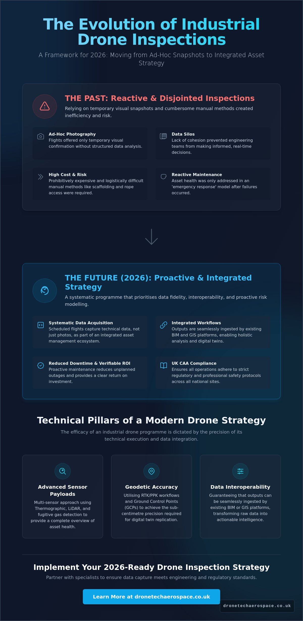
Relying on a basic drone inspection or survey is no longer a sufficient strategy for a corporate asset integrity management programme. We all recognise that manual scaffolding and rope access are prohibitively expensive and logistically cumbersome, especially for large-scale infrastructure. Whilst ad-hoc flights offer temporary visual snapshots, they often fail to address the core requirement of a unified industrial drone inspection strategy; the seamless integration of aerial data into existing engineering workflows. This lack of cohesion often results in data silos that prevent engineering teams from making informed, real-time decisions regarding asset health.
This article outlines a robust framework for 2026 that moves beyond simple photography to prioritise data interoperability and proactive risk modelling. You'll learn how to dismantle the barriers between aerial data collection and engineering analysis whilst ensuring strict UK CAA compliance across all national sites. We'll examine the technical methodologies required to synchronise high-resolution imagery with BIM and GIS platforms, providing a clear pathway to reduced operational downtime and a verifiable return on investment for complex industrial portfolios.
Key Takeaways
Transition from ad-hoc aerial photography to a systematic industrial drone inspection strategy that aligns with 2026 integrated asset management standards.
Identify the specific sensor payloads and geodetic requirements, such as RTK and thermal sensors, necessary to deliver high-precision technical data.
Evaluate the commercial benefits of proactive UAV deployment as a method to mitigate the high costs and safety risks associated with manual scaffolding.
Establish a clear roadmap for integrating aerial data into existing BIM and GIS workflows to eliminate data silos and support engineering decision-making.
Mitigate corporate liability by ensuring all operations adhere to strict UK CAA compliance and professional safety protocols across multiple national sites.
Table of Contents
Defining a Modern Industrial Drone Inspection Strategy in 2026
The transition from rudimentary aerial photography to a sophisticated industrial drone inspection strategy represents a fundamental pivot in how asset integrity is maintained in 2026. Industrial operators have moved beyond the era of ad-hoc flights, replacing them with systematic, technical data acquisition programmes that prioritise precision over simple visual confirmation. Modern UAVs are no longer viewed as isolated tools; they're integral components of a wider Integrated Asset Management ecosystem. This evolution requires a multi-sensor approach (utilising thermographic, LiDAR, and fugitive methane gas detection payloads) to provide a comprehensive overview of site health. The diversification of UAV applications in infrastructure inspections has expanded the scope of what is possible within a single deployment, allowing for the simultaneous capture of multiple data streams.
A robust strategic framework rests on three critical pillars: safety, data fidelity, and interoperability. Safety protocols must be ingrained into the flight planning phase, ensuring that every operation adheres to stringent risk mitigation standards. Data fidelity ensures that the information captured is accurate enough for engineering analysis, whilst interoperability guarantees that these outputs can be seamlessly ingested by existing digital twin or BIM (Building Information Modelling) platforms. By standardising these elements, businesses can transform raw aerial footage into actionable intelligence that informs long-term capital expenditure decisions.
From Reactive to Proactive Asset Management
The primary advantage of a structured aerial programme is the shift from reactive 'emergency response' to scheduled preventative maintenance cycles. Strategic aerial audits allow engineering teams to identify structural fatigue (such as micro-fissures in concrete or thermal anomalies in electrical components) whilst they remain invisible to the naked eye. This proactive stance significantly reduces the likelihood of unplanned outages. Consistent data capture provides a verifiable chronological record of asset condition, which is essential for drone insurance risk assessments and loss adjusting. Having a high-resolution, dated ledger of an asset's state simplifies the claims process and demonstrates a commitment to rigorous maintenance standards.
The UK Industrial Context: Scale and Complexity
UK infrastructure presents a unique set of challenges, ranging from the delicate requirements of heritage site inspections to the vast, exposed environments of offshore wind-farm construction surveys. Managing these diverse assets at a national scale requires a standardised operational manual that ensures consistency across every site location, regardless of geographic disparity. In high-stakes civil engineering environments, professional accountability is non-negotiable. It's not enough to simply capture imagery; the provider must demonstrate a deep understanding of the technical and regulatory landscape, ensuring that all data is gathered legally and to a standard that supports critical safety certifications.
Technical Pillars: Sensors, Payloads, and Geodetic Accuracy
The efficacy of a professional industrial drone inspection strategy is dictated by the precision of its technical execution. It's not merely about flight time; it's about the deliberate selection of sensor payloads to meet specific industrial requirements. High-density point clouds generated during Drone Topographical Land Surveys require LiDAR sensors with high pulse rates to penetrate dense vegetation and capture the true ground surface. This level of data density is critical for civil engineering projects where even a few centimetres of deviation can compromise volumetric calculations or site drainage models. For projects requiring this level of technical rigour, engaging a specialist for Drone Industrial Site Inspections & Surveys ensures that data capture meets both engineering and insurance standards.
To achieve the sub-centimetre precision required for digital twin replication, operators must utilise Real-Time Kinematic (RTK) positioning or Post-Processed Kinematic (PPK) workflows, often supplemented by physical Ground Control Points (GCPs). Whilst FAA regulations for commercial drone use provide a high-level safety framework often referenced globally, UK-based industrial sites operate under the specific oversight of the Civil Aviation Authority (CAA). Compliance with PDRA-01 or complex Operational Authorisations is mandatory for flights in congested industrial zones, ensuring that technical data acquisition never compromises site safety protocols. This regulatory adherence is the bedrock of professional accountability in high-stakes environments.
Sensor fusion (the simultaneous capture and overlay of visual and thermographic data) provides a depth of insight that isolated datasets cannot match. By mapping thermal anomalies directly onto a high-resolution 3D mesh, engineers can pinpoint the exact location of a failing insulator or a structural heat leak. This integrated approach is essential for large-scale asset management, where identifying a fault is only half the task; the data must also provide the spatial context required for repair teams to act. A successful industrial drone inspection strategy treats the drone as a flying data hub, synchronising multiple sensors to create a comprehensive digital record of the asset.
Advanced Gas Detection and Environmental Compliance
Strategic Drone Fugitive Methane Gas Surveys have become indispensable for pipeline management and meeting stringent ESG (Environmental, Social, and Governance) reporting requirements. Modern Tuneable Diode Laser Absorption Spectroscopy (TDLAS) sensors allow for the quantification of emissions in real-time, identifying leaks that traditional 'sniffing' methods might miss due to accessibility constraints. This transition from manual spot-checks to aerial analytical modelling enables operators to demonstrate industrial compliance with verifiable, georeferenced data.
Thermal Imaging for Infrastructure and Energy
Thermographic audits provide an early-warning system for electrical substations and renewable energy assets. By identifying 'hot spots' in solar arrays or wind turbine components, operators can intervene before a catastrophic failure occurs. Standardising these surveys allows for year-on-year delta analysis, where the rate of degradation is tracked over time. This longitudinal data is vital for life-extension programmes in heavy industry, ensuring that maintenance budgets are allocated to the assets exhibiting the highest risk of thermal failure.
For those managing smaller-scale residential installations, the same principles of technical scrutiny apply; detailed resources such as margavsolar.com can help homeowners select systems designed to withstand the specific challenges of the UK climate.
The ROI Framework: Proactive vs. Reactive Inspection Models
Quantifying the return on investment for a robust industrial drone inspection strategy requires a shift in focus from operational expenditure to long-term asset lifecycle value. Traditional inspection methods, such as manual scaffolding or rope access, involve significant logistical lead times and high capital costs. For instance, the assembly of scaffolding for a standard industrial chimney or storage tank can take several days before an inspector even sets foot on the structure. Rapid UAV deployment eliminates these preparatory phases, allowing for high-resolution data capture to commence within hours of arriving on site. This efficiency directly addresses the 'Cost of Inaction', where delayed inspections often lead to undetected structural degradation and subsequent catastrophic failure.
In heavy industry and manufacturing, the primary financial driver is the reduction of operational downtime. Aerial data allows for 'live' inspections of many assets, such as flare stacks or cooling towers, whilst they remain in production. When an outage is necessary, drone data provides a precise map of required repairs, ensuring that maintenance teams are deployed with the correct materials and instructions. This targeted approach improves Mean Time Between Failures (MTBF) by ensuring that preventative maintenance is based on empirical data rather than estimated wear cycles. Maintaining a comprehensive historical data trail provides an additional insurance benefit. By demonstrating a proactive approach to risk management with georeferenced, time-stamped evidence, industrial operators can often negotiate lower risk premiums with their underwriters.
Mitigating Risk in High-Hazard Environments
The elimination of 'Work at Height' risks is perhaps the most immediate safety advantage of an aerial programme. By utilising remote sensing, personnel are kept out of harm's way, significantly reducing the liability associated with high-hazard site audits. This is particularly relevant for Internal & Confined Space Inspections, where ball-and-cage drones can navigate boilers, tanks, and culverts that would otherwise require dangerous human entry. These specialised UAVs provide a 'Single Source of Truth' for health and safety audits, offering a verifiable visual record that satisfies both internal compliance officers and external regulatory bodies like the Health and Safety Executive (HSE).
Calculating the True Value of Aerial Data
To accurately measure success, organisations must move beyond 'cost-per-flight' and adopt 'value-per-data-point' metrics. The integration of 3D measured building models into renovation projects or heritage preservation efforts can save thousands of pounds in rework costs by identifying structural misalignments early in the design phase. This technical precision ensures that every flight contributes to a wider strategy of asset longevity and financial accountability. Return on investment in this context is defined as the total financial saving achieved through the early detection of structural anomalies, the reduction of manual labour hours in hazardous zones, and the minimisation of unplanned asset downtime.
Implementation Roadmap: Integrating UAV Data into BIM and GIS
The success of a professional industrial drone inspection strategy is measured by the seamless transition from raw sensor capture to actionable engineering insights. This data journey requires a structured processing pipeline where high-resolution imagery is transformed into georeferenced point clouds and 3D meshes. For large-scale infrastructure, developing a Digital Twin strategy is essential; it creates a dynamic digital replica that evolves alongside the physical asset. Organisations must choose between cloud-based hosting for rapid stakeholder collaboration and local processing for sensitive industrial sites where data sovereignty is paramount. This decision often hinges on the internal security protocols of the facility being inspected.
Data silos often hinder the effectiveness of aerial programmes. To prevent this, UAV outputs must maintain strict compatibility with AutoCAD, Revit, and other GIS platforms. This technical interoperability ensures that engineering teams can ingest drone-derived data directly into their existing design environments without manual conversion. When field data flows directly into the project's central model, it eliminates the disconnect between the "as-designed" and "as-built" states. This integration is the only way to ensure that the industrial drone inspection strategy delivers a measurable reduction in project rework costs.
BIM Integration and LOD Standards
High-precision drone data allows for the creation of models at Level of Development (LOD) 300 and above, providing the geometric accuracy required for detailed structural analysis. Using orthomosaic mapping alongside these models enables continuous "as-built" verification throughout the construction phase. This level of detail is critical for clash detection; it allows engineers to identify potential structural conflicts in three dimensions before they manifest on the physical site. By populating BIM models with real-world data, project managers can verify that subcontractors are adhering to exact design specifications.
Volumetric Analysis for Stockpile Management
Standardising Drone Stockpile Volume Surveys provides a reliable framework for monthly inventory audits in sectors like mining and civil engineering. By achieving sub-centimetre accuracy in material displacement calculations, businesses can automate volumetric reporting for large-scale earthworks and quarries. This precision ensures that stock levels are always accounted for with absolute financial accountability, reducing the risks associated with manual estimation. For organisations seeking to modernise their inventory tracking, this automated approach provides a verifiable audit trail that satisfies both operational and financial requirements.
To ensure your aerial data integrates seamlessly with your existing BIM and GIS workflows, consult the technical specialists at Drone Tech Aerospace (DTA).
Partnering for Scale: Why Professional Accountability Matters
The decision between developing an in-house UAV department and partnering with a specialist provider is a critical juncture for any large-scale organisation. Whilst an internal team offers perceived control, the reality often involves substantial hidden costs, including pilot currency training, equipment depreciation, and the complex management of CAA Operational Authorisations. A professional partner provides immediate access to a diverse fleet and established safety protocols, effectively transferring operational risk away from the client. For national-scale projects, this level of professional accountability is essential to ensure that an industrial drone inspection strategy is executed with consistent technical rigour across multiple geographic regions.
Future-proofing is equally vital as the industry moves toward standardised Beyond Visual Line of Sight (BVLOS) operations. Preparing for these long-range missions requires a partner capable of managing the heightened regulatory and technical demands of 2026 infrastructure monitoring. Drone Tech Aerospace provides this industrial-grade reliability, offering a scalable model that evolves alongside both technological advancements and shifting UK regulations. By outsourcing to a high-capacity specialist, organisations ensure that their asset integrity programmes are supported by seasoned veterans who prioritise precision and verifiable data delivery. This partnership model allows engineering teams to focus on interpreting insights rather than managing flight logistics.
Specialised Solutions for Heritage and Heavy Industry
Maintaining the integrity of heritage structures requires a non-invasive approach that traditional methods cannot provide. Strategic internal audits using specialised cage drones allow for the close-up inspection of delicate masonry and timber without the need for physical contact. Similarly, managing complex inspections for telecommunications towers and renewable energy farms demands a partner with the technical breadth to handle varying sensor requirements. This expertise is particularly valuable for insurance risk and loss adjusters, who require professional-grade data to accurately assess liabilities and structural conditions in high-hazard environments where manual access is restricted.
Next Steps: Launching Your 2026 Drone Strategy
Transitioning to a modern aerial programme is best achieved through a phased implementation. We recommend starting with a high-value pilot project to demonstrate the data workflow and confirm the interoperability of UAV outputs with your internal engineering systems. Once the value-per-data-point is established, the programme can be scaled across national portfolios with a consistent technical partner to ensure data uniformity. This methodical approach ensures that every flight contributes to a robust industrial drone inspection strategy that delivers measurable ROI. To begin this transition, consult with Drone Tech Aerospace to develop your bespoke industrial inspection strategy and secure the long-term longevity of your assets.
Securing Asset Longevity Through Technical Precision
Implementing a sophisticated industrial drone inspection strategy is no longer a peripheral consideration for corporate asset managers; it's a technical necessity. We've established that the transition from simple visual snapshots to high-fidelity data integration (specifically within BIM and GIS ecosystems) is the only viable path to reducing operational downtime. By prioritising geodetic accuracy and multi-sensor fusion, organisations can move from reactive repairs to a predictive maintenance model that satisfies both engineering requirements and insurance standards.
Success in this field requires a partner with a proven track record in high-stakes environments. Drone Tech Aerospace brings 10+ years of operational excellence to the UK market, offering national coverage for large-scale infrastructure and construction projects. Our specialised ball/cage-drone technology ensures that even the most complex confined space inspections are handled with absolute precision and safety.
Partner with Drone Tech Aerospace for precision industrial aerial inspections to ensure your asset integrity programme meets the rigorous demands of 2026. Your transition to a data-driven aerial programme starts with a focus on technical accountability and verifiable results.
Frequently Asked Questions
What are the primary benefits of an industrial drone inspection strategy?
The primary benefits include a significant reduction in manual labour costs and the total elimination of safety risks associated with working at height or in hazardous zones. A structured industrial drone inspection strategy enables high-frequency data capture that identifies structural anomalies before they escalate into critical failures. This methodical approach ensures that asset integrity programmes remain data-driven; providing a verifiable audit trail for both internal compliance and external insurance underwriters.
How do drones ensure safety in confined space inspections?
UAVs ensure safety by removing the requirement for human personnel to enter oxygen-depleted or structurally unstable environments. Specialised ball-and-cage drones are engineered to withstand collisions within boilers, tanks, and culverts, providing high-resolution visual data whilst maintaining a safe distance for the flight team. This approach reduces the logistical burden of confined space entry permits and the high cost of standby rescue teams typically required for manual entry.
Can drone survey data be integrated directly into BIM software?
Drone survey data is fully compatible with BIM software through the generation of high-density point clouds and 3D meshes. These technical outputs are exported in standard formats such as .LAS or .OBJ, allowing engineering teams to overlay as-built data directly onto design models in platforms like Revit or AutoCAD. This synchronisation is a core component of a modern industrial drone inspection strategy; ensuring that digital twins reflect real-world conditions with absolute precision.
What UK CAA regulations apply to industrial drone inspections in 2026?
Industrial operations in 2026 must adhere to specific Civil Aviation Authority (CAA) frameworks, including the PDRA-01 for standard scenarios or bespoke Operational Authorisations for complex industrial zones. Remote pilots must hold a valid Flyer ID and Operator ID whilst ensuring all flights comply with strict altitude and distance limitations defined in their risk assessments. Professional providers manage these regulatory requirements to ensure full legal accountability and site safety on behalf of the client.
How accurate are drone-based volumetric stockpile surveys?
Drone-based volumetric surveys achieve sub-centimetre accuracy when supported by RTK (Real-Time Kinematic) technology and physical ground control points. This level of precision allows for the exact calculation of material displacement in quarries, earthworks projects, and industrial stockpile yards. The resulting data provides a verifiable audit trail for inventory management that is significantly more reliable than traditional manual estimation methods, which often suffer from human error and limited perspective.
What is the difference between reactive and proactive drone maintenance?
Reactive maintenance involves repairing assets only after a failure has occurred, which typically leads to unplanned downtime and high emergency repair costs. Proactive maintenance uses scheduled drone inspections to identify early signs of degradation, such as thermal anomalies in electrical components or micro-fissures in concrete. This foresight allows for planned interventions during scheduled outages, effectively extending the overall lifecycle of the asset and reducing long-term capital expenditure.
Do I need a special drone for internal heritage site inspections?
Internal heritage site inspections require specialised non-invasive drones equipped with protective cages to prevent any physical contact with delicate masonry or historical artefacts. These UAVs utilise advanced stabilised sensors to capture high-resolution imagery in low-light conditions without the need for intrusive scaffolding or high-intensity lighting. This ensures that structural assessments are conducted with minimal risk to the fabric of the building whilst providing engineers with a comprehensive view of hard-to-reach areas.

How does aerial methane detection improve industrial compliance?
Aerial methane detection utilises Tuneable Diode Laser Absorption Spectroscopy (TDLAS) sensors to identify and quantify fugitive gas emissions in real-time. This capability is essential for meeting UK environmental compliance standards and ESG reporting requirements for the energy and manufacturing sectors. By mapping gas plumes from the air, operators can pinpoint leak sources across vast pipeline networks or industrial plants with a level of efficiency and safety unattainable by ground-based sniffing crews.


Comments