
Professional Drone Topographical Survey Services in the UK
- John Palmer (Director, DTA)

- Jun 3
- 13 min read
Updated: Jun 5
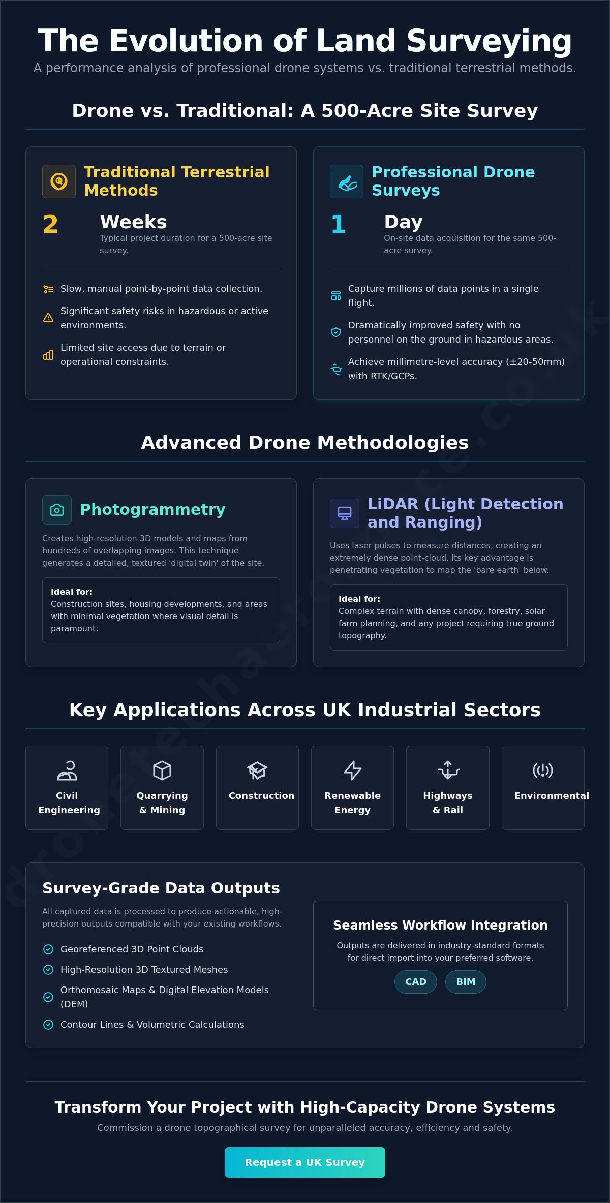
A 500-acre land survey that traditionally required two weeks of manual labour can now be executed with absolute precision within one day onsite. Most Project Managers in construction, industry, utilities, and renewable energy now recognise that slow terrestrial data collection leads to significant timeline slippage and introduces unnecessary safety risks in hazardous environments (especially active construction, quarry or landfill sites). This article demonstrates how a professional drone topographical survey UK wide delivers the high-precision UAV data collection required to transform land surveying accuracy, efficiency and operational safety.
You'll learn how millimetre-accurate 3D models and seamless integration into existing CAD or BIM workflows provide the reliability required for large-scale UK infrastructure projects. We examine the technical advantages of RTK positioning and the superior data density achieved through professional-grade aerial sensors. This overview covers the critical components of modern surveying, including rapid site turnaround and the strict adherence to Civil Aviation Authority (CAA) regulatory frameworks. By the end of this guide, the advantages of transitioning from traditional methods to high-capacity drone systems will be clear.
##Table of Contents
Defining Drone Topographical Surveys in the UK Construction Landscape
Advanced Methodologies: LiDAR vs Photogrammetry for High-Precision Mapping
Performance Analysis: Drone Surveying vs Traditional Terrestrial Methods
Data Outputs and Workflow Integration for Engineering and Infrastructure
Commissioning Drone Tech Aerospace for National Infrastructure Projects
##Defining Drone Topographical Surveys in the UK Construction Landscape
A topographical survey provides a precise, three-dimensional representation of a site's physical features, including both natural terrain and man-made structures. Within the UK construction, civil engineering, and renewable (solar & wind) energy sectors, the adoption of **drone topographical surveys UK** wide has become the standard for projects requiring rapid data acquisition without compromising on accuracy. These surveys go beyond simple two-dimensional mapping; they provide the foundational spatial data required for architectural design, volumetric analysis, and site planning. By utilising high-specification UAVs, surveyors can capture exhaustive detail that would be impossible to achieve through ground-based methods alone.
Traditional terrestrial methods, involving total stations and GNSS rovers, remain highly accurate but are often restricted by the pace of manual point collection. UAVs bridge this gap by capturing millions of data points in a single flight, representing a significant shift in modern UK land surveying standards. This transition from ground-based to aerial acquisition allows for a more comprehensive understanding of site conditions, particularly on large-scale infrastructure projects where speed and safety are paramount.
The Distinction Between Visual Inspection and Measured Survey
It is vital to distinguish between a standard drone inspection and a more technical measured drone survey. A visual inspection prioritises high-resolution media, such as 4K video or still photography, to identify surface defects like structural cracks or corrosion. Whilst these assets are valuable for maintenance, they lack the mathematical data required for engineering. A measured survey relies on an [unmanned aerial photogrammetric survey](https://en.wikipedia.org/wiki/Unmanned_aerial_photogrammetric_survey) to generate georeferenced data points. Each pixel is tied to a specific coordinate system, allowing for the creation of accurate 3D models. Achieving survey-grade accuracy, often within a range of ±20-50mm, necessitates the use of Real-Time Kinematic (RTK) technology or Post-Processed Kinematic (PPK) workflows, supported by physical Ground Control Points (GCPs). Without this technical framework, aerial data remains purely illustrative rather than analytical.
Key Applications Across UK Industrial Sectors
The utility of aerial topographical data extends across multiple high-stakes sectors. In civil engineering, these surveys facilitate precise earthwork calculations and site levelling. Quarrying and mining operations utilise UAV data for periodic inventory management, calculating stockpile volumes and monitoring void depletion with high frequency. Environmental agencies and land developers rely on these models for flood risk assessments and drainage strategy. Within the UK's national infrastructure, aerial surveying supports highways mapping and rail corridor management, where traditional terrestrial methods would require extensive road closures or pose significant risks to personnel. The transition to aerial methods ensures that these complex environments are mapped with exhaustive detail whilst maintaining the highest safety standards.
##Advanced Methodologies: LiDAR vs Photogrammetry for High-Precision Mapping
Selecting the optimal methodology for a **drone topographical survey UK** wide is a decision driven by terrain complexity and the required deliverables. High-precision mapping is not a singular process; it is a technical choice between passive optical sensors and active laser systems. For project managers in the construction, civil engineering, and renewable (solar & wind) energy sectors, understanding the fundamental differences in [LiDAR vs. Photogrammetry](https://www.jouav.com/blog/lidar-vs-photogrammetry.html) is critical for ensuring data integrity from the outset. Both technologies provide survey-grade results, yet their applications vary significantly based on site conditions.
Photogrammetry: Creating High-Resolution Digital Twins
Photogrammetry operates by capturing a high volume of overlapping images from multiple angles. These images are then stitched together to form a georeferenced orthomosaic (a geometrically corrected map) or a 3D textured mesh. This methodology is particularly effective for construction sites, residential housing developments, and areas with minimal vegetation. It provides an exceptionally detailed visual record, allowing stakeholders to inspect site features with millimetre-level clarity. When executed with high-resolution full-frame sensors, photogrammetry creates a comprehensive digital twin that is ideal for architectural visualisation and site planning. To see how these plans are executed in reality, you can visit Swiss Build Ltd, specialists in high-quality residential and commercial construction.
LiDAR Technology for Complex UK Terrain
LiDAR (Light Detection and Ranging) utilises active laser pulses to measure the distance between the sensor and the ground. This capability is essential for mapping the "bare earth" surface in areas with dense canopy or significant vegetation overgrowth. In the UK, where heritage sites and rural infrastructure projects such as solar farms often involve challenging greenery, LiDAR provides a vital reliable means of capturing true ground topography. It generates a dense point-cloud (typically ranging from 100 to 500 points per square metre). LiDAR's advantage over to photogrammetry lies in its ability to penetrating shadows or low-light environments, thus delivering readings of "true ground" below foliage. This level of technical precision is why many industrial partners choose our specialist [Drone Topographical Land Surveys](https://dronetechaerospace.co.uk/) for complex site assessments.
The reliability of these methodologies is underpinned by two factors: sensor quality and the rigorous use of Ground Control Points (GCPs). Professional-grade results require the use of integrated systems (such as the DJI Matrice 400 & 350 RTK) paired with high-performance payloads. While Real-Time Kinematic (RTK) positioning provides high relative accuracy, the inclusion of physical GCPs ensures absolute spatial accuracy across the entire survey area. This methodical approach guarantees that the final 3D models are not only visually impressive but are mathematically sound for engineering applications.
Ultimately, it is not a matter of Photogrammetry versus LiDAR for your project. More often now we deliver a mixture of both datasets on large infrastructure drone topographical surveys, applying each methodology as necessary to the varying site conditions, and then integrating the datasets to deliver the best results across all terrains.
##Performance Analysis: Drone Surveying vs Traditional Terrestrial Methods
The efficiency of a **drone topographical survey** is most evident when contrasted against the physical limitations of traditional terrestrial methods. While a standard land survey using total stations or GNSS rovers requires a surveyor to manually record discrete points (often resulting in a few hundred measurements per day), a UAV captures millions of data points in a fraction of the time. Research indicates that a 500-acre site that would traditionally require two weeks of manual labour, yet can be fully surveyed using a drone in only one day. This acceleration of site turnaround is a primary driver for large-scale infrastructure and construction projects where delays translate directly into increased overheads.
Cost-efficiency becomes particularly pronounced on projects exceeding five hectares. The initial mobilisation of a professional drone team is offset by the rapid acquisition of exhaustive site data, whereas traditional methods scale linearly in both cost and time. By choosing aerial acquisition, project managers can reallocate resources to analysis and engineering rather than data collection. It's a shift from labour-intensive fieldwork to data-intensive analysis.
Enhanced Safety and Risk Mitigation
Safety is a non-negotiable priority in construction and industrial environments. Traditional surveying often mandates that personnel traverse hazardous terrain, such as unstable stockpiles, steep embankments, or active quarry floors. Utilising a drone removes the requirement for "boots on the ground" in these high-risk zones, significantly reducing the potential for workplace accidents. This approach ensures strict compliance with UK Health and Safety standards (specifically CDM 2015 regulations) whilst maintaining operational continuity. In sectors like mining or landfill management, where void calculations are frequent, the ability to collect data from a safe distance is a critical operational advantage.
Beyond data collection, maintaining operational safety during the physical stages of a project is equally vital. For infrastructure developments requiring heavy lifting or equipment transport, Bewlake Lift & Haul Ltd offers the specialist crane hire and haulage expertise needed to navigate complex sites safely and efficiently.
Data Density and Comprehensive Site Coverage
The technical superiority of aerial methods lies in the density of the resulting data. Terrestrial surveys rely on sampled points, which can leave significant "data gaps" between measured locations. In contrast, a drone survey produces a continuous point-cloud or 3D mesh, capturing every centimetre of the site's surface. This comprehensive coverage prevents costly construction errors that arise from overlooked terrain variations. The digital nature of the output allows engineers to revisit the data retrospectively. If a specific feature wasn't identified as a priority during the initial brief, it can be measured from the existing 3D model without the need for a secondary site visit. This level of data integrity provides a professional assurance that sampled terrestrial points cannot match.
##Data Outputs and Workflow Integration for Engineering and Infrastructure
High-precision data is only as valuable as its ability to be integrated into existing engineering workflows. A professional **drone topographical survey** produces a suite of standardised digital deliverables that serve as the foundation for modern Building Information Modelling (BIM). These datasets provide a level of technical detail that ensures project managers and engineers aren't working from outdated or inaccurate site records.
Essential deliverables typically include:
Point-Clouds: A dense 3D dataset containing millions of georeferenced points.
Digital Elevation Models (DEMs): Digital models of the bare-earth terrain.
Orthomosaics: A high-resolution, distortion-free aerial map of the site.
3D Textured Meshes: Photorealistic models for visualisation and stakeholder engagement.
2D Contour & Point-Grid Drawings: Traditional CAD-ready files for engineering design.
It's a process that moves beyond simple photography to provide engineering-grade assets. Unlike legacy systems that require manual digitisation, these files are natively compatible with industry-standard platforms such as AutoCAD Civil 3D and Bentley MicroStation. The interoperability of these datasets allows multidisciplinary teams to collaborate within a single source of truth. 3D textured meshes provide a visceral, highly accurate visualisation of site topography; this enables stakeholders to conduct virtual site reviews without leaving the office. This digital-first approach ensures architectural and civil-engineering designs are grounded in real-world spatial constraints, reducing the risk of clashes during construction.
From Raw Data to Actionable CAD Drawings
Extracting 2D planimetric features, such as kerb lines and building footprints, from 3D aerial data is a rigorous process. We ensure all CAD outputs adhere to specific UK surveying and architectural standards, providing engineers with layered DWG or DXF files ready for immediate use. By utilising georeferenced point-grids, we provide the level of detail and accuracy required for complex drainage design and highway alignment.
Volumetric Analysis and Stockpile Monitoring
For sectors involved in earthworks and resource management, the ability to conduct precise [Drone Stockpile Volume Surveys](https://dronetechaerospace.co.uk/) is transformative. Traditional estimation methods often rely on sampled measurements that can lead to significant discrepancies. UAV data collection captures the entire surface area of a spoil heap or excavation void, resulting in volumetric calculations with superior accuracy. This data is essential for landfill void monitoring and ensuring material excavation stays within budgetary parameters.
The Importance of Data Processing Expertise
Nowadays we are constantly barraged by articles claiming that little or no engineering and mathematical expertise is required to achieve professional results in surveying in the advent of drone technology and its supporting software. While there is some truth in the dramatic enabling capabilities of software, it is frankly untrue to say that it replaces fundamental scientific and engineering expertise. Delivery high-precision data from a professional drone topographical survey requires complex processing. At DTA, we have the background in IT necessary to build our own enterprise data processing servers, customised to the very specific needs of survey data, that enables us to process your drone topographical survey data efficiently and reliably at a scale capable of handing surveys greater than 1,000 Hectares.
##Commissioning Drone Tech Aerospace for National Infrastructure Projects
Drone Tech Aerospace (DTA) operates as a premium, high-capacity partner for industrial and corporate clients requiring absolute precision. With a 12-year track record in executing complex technical surveys across the UK, the firm has established itself as a leader in the national infrastructure sector. Every **drone topographical survey UK** wide is treated as a bespoke operation. We design each flight plan and data processing workflow to meet the specific spatial and analytical requirements of the project, whether it involves construction, civil engineering, heavy industry, renewable energy, or heritage preservation.
Professional accountability is underpinned by full Civil Aviation Authority (CAA) authorisation and comprehensive commercial insurance. DTA pilots hold the necessary certifications (including A2 CofC and GVC) required for complex operations in congested or high-risk areas. This rigorous adherence to regulatory frameworks ensures that data collection is not only mathematically accurate but legally robust. It provides the security and assurance that corporate stakeholders require when managing high-stakes assets. Our operational scale allows us to deploy specialised equipment (such as the DJI Matrice series) to any location in the United Kingdom, ensuring consistent data quality across multi-site programmes.
Expertise in High-Stakes and Confined Environments
DTA possesses the specialised capability to conduct internal and confined space inspections using advanced ball and cage-drone technology. This creates a unique technical synergy between external topographical mapping and internal structural assessments. In sectors such as renewable energy (specifically wind turbine and solar farm construction) and heritage restoration, the ability to transition from wide-area aerial surveys to granular internal inspections provides a holistic data package. This integrated approach allows engineers to identify structural anomalies whilst maintaining a precise georeferenced understanding of the surrounding terrain.
A Partner for Long-Term Construction Monitoring
Large-scale infrastructure projects require more than a single point-in-time survey to remain on schedule. DTA serves as a long-term partner, providing recurring site monitoring to track project evolution against initial topographical baselines. This ongoing data collection allows project leads to identify deviations from design early, preventing costly remedial works. As a national provider, we maintain the reliability and professional gravity required to support the UK's most demanding engineering projects from inception to completion.
Contact Drone Tech Aerospace for a technical consultation on your next survey to ensure your project data meets the highest industry standards.
Optimising Infrastructure Precision with Advanced Aerial Data
The integration of professional UAV systems into land surveying marks a fundamental shift in how UK infrastructure is planned and executed. It's a move away from sampled terrestrial points towards exhaustive, millimetre-accurate digital twins. By prioritising high-density point-clouds and survey-grade methodologies (such as RTK-enabled LiDAR and photogrammetry), project managers can secure a level of terrain detail that was previously unattainable. A professional **drone topographical survey UK** wide provide the mathematical certainty required for complex engineering whilst ensuring full interoperability with established BIM and CAD workflows.
Drone Tech Aerospace brings over 12 years' of industrial UAV expertise to every operation, supported by full CAA authorisation and comprehensive commercial insurance. We specialise in high-accuracy CAD and BIM deliverables that meet the rigorous demands of national infrastructure projects.
We invite you to [Request a Technical Quote for Your UK Drone Survey](https://www.dronetechaerospace.co.uk/drone-land-topographical-survey) and secure a high-performance partner for your next development. We look forward to enhancing your site accuracy and operational efficiency.
##Frequently Asked Questions
What is the accuracy of a drone topographical survey?
Survey-grade accuracy for a **drone topographical survey UK** is typically within the range of ±2-3cm horizontally and ±2-5cm vertically. This level of precision is achieved through the use of Real-Time Kinematic (RTK) positioning and the strategic placement of physical Ground Control Points (GCPs). These benchmarks ensure that the aerial data is tied to the national coordinate system with absolute spatial integrity. Such accuracy is sufficient for the majority of civil engineering and construction applications.
How much does a drone topographical survey cost in the UK?
The cost of an aerial survey is determined by several technical variables, including the total acreage of the site, terrain complexity, and the specific deliverables required. Projects requiring LiDAR for dense vegetation penetration generally involve higher operational costs than standard photogrammetry missions. Other factors include the level of vertical accuracy needed and the complexity of the final CAD or BIM integration. Each project necessitates a bespoke assessment to determine the appropriate sensor payload and flight duration. It is certain though, that a drone topographical survey above 10 Hectares will be significantly lower in cost than traditional survey methods.
Is a drone survey as accurate as a traditional land survey?
Modern UAV systems, operated by suitably skilled survey teams, match the precision of traditional terrestrial methods whilst providing significantly higher data density. While a total station captures discrete points manually, a drone captures millions of coordinates to create a continuous surface model. This comprehensive coverage eliminates the risk of missing critical terrain variations between sampled points. Traditional methods remain relevant for establishing primary site benchmarks, but drones are the superior choice for wide-area topographical mapping.
What regulations apply to drone surveying on UK construction sites?
Commercial operations on UK construction sites must adhere to strict Civil Aviation Authority (CAA) regulations for a **drone topographical survey**. This includes the requirement for an Operator ID and a Flyer ID for the pilot. Most industrial projects necessitate an A2 Certificate of Competency (A2 CofC) or a General Visual Line of Sight Certificate (GVC). From January 1, 2026, mandated drones must also broadcast Remote ID, ensuring full compliance with the latest UK airspace safety standards.
Can drones perform topographical surveys in wooded or high-vegetation areas?
Drones can execute high-precision surveys in wooded areas by utilising LiDAR (Light Detection and Ranging) sensors. Unlike photogrammetry, which relies on visual line-of-sight to the ground with good lighting conditions, LiDAR pulses penetrate gaps in the canopy to reach the "bare earth" surface even where areas are dark. With additional expert processing this allows for the creation of accurate Digital Terrain Models (DTMs) even in environments with dense vegetation or high foliage. It is the preferred methodology for rural infrastructure and heritage site assessments.
What file formats are provided after a drone land survey?
Survey data is provided in industry-standard formats to ensure seamless integration with existing engineering software. Common deliverables include .DWG and .DXF files for AutoCAD, .LAS or .LAZ for point-clouds, and .TIFF for high-resolution orthomosaics. We also provide .OBJ or .FBX files for 3D textured meshes used in BIM environments. These standardised outputs allow multidisciplinary teams to utilise the data immediately for design and volumetric analysis.
How long does it take to receive the data from a UAV survey?
Data acquisition is typically completed within a matter of hours, representing a significant time saving over traditional methods. The subsequent processing and data refinement phase generally takes between 24 and 72 hours, depending on the scale of the site and the complexity of the CAD deliverables. Large-scale infrastructure projects requiring manual feature extraction may require additional time. This rapid turnaround allows project leads to maintain tight construction schedules without data-related delays.
Do I need to clear the site before a drone survey takes place?
It is not strictly necessary to clear the site, as modern post-processing software can filter out transient objects like vehicles or plant equipment. However, removing large obstructions improves the visibility of the ground surface for both photogrammetric and LiDAR missions. For sites with significant debris or vegetation, LiDAR is utilised to bypass surface clutter and capture the true topography. Our technical team provides specific pre-flight guidance based on the unique conditions of your industrial or construction environment.
To discuss your project with a technical specialist, contact Drone Tech Aerospace for a professional consultation.
Over 12 years' of industrial UAV expertise
Full CAA operational authorisation and comprehensive insurance
Specialists in high-accuracy CAD and BIM deliverables


Comments