
Mastering Volumetric Survey Techniques: A Professional Guide to Precision Measurement
- John Palmer (Director, DTA)

- 1 day ago
- 12 min read
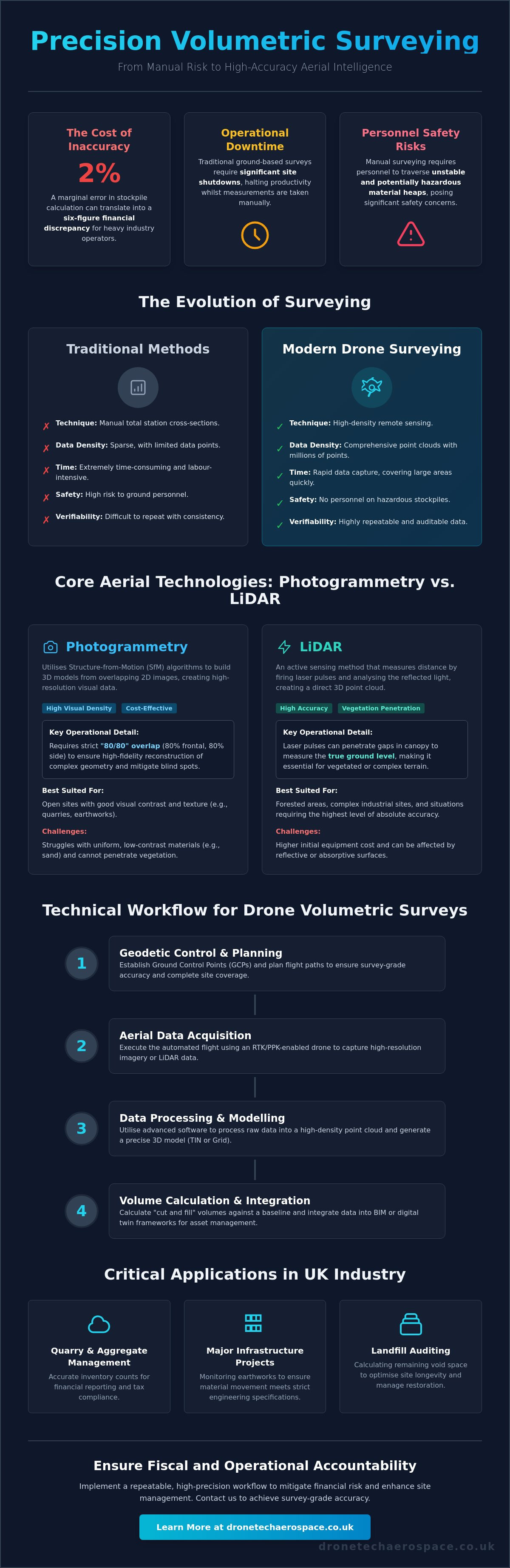
A marginal error of just two per cent in a large-scale stockpile calculation often translates into a six-figure financial discrepancy for heavy industry operators. Professional site managers recognise the inherent limitations of manual measurement, particularly the operational downtime and safety risks associated with ground-based personnel traversing unstable material heaps. Implementing advanced volumetric survey techniques is no longer a matter of convenience; it is a critical geodetic requirement for maintaining absolute fiscal and operational accountability in 2026.
This guide provides the technical framework to implement a repeatable, high-precision workflow using the latest enterprise-grade aerial platforms (including RTK-enabled drones for survey-grade deliverables). We will detail the methodologies for generating high-density point clouds (utilising advanced processing software such as DJI Terra version 5.2.5), the strategic application of LiDAR in vegetated or complex terrain, and the specific data processing steps required for seamless BIM integration. This methodical approach ensures that your volume data remains consistent, verifiable, and compliant with all current Remote ID and registration standards enforced across the industry.
Key Takeaways
Understand the transition from traditional manual cross-sectioning to high-density remote sensing for precise material quantity assessment.
Evaluate the technical criteria for selecting between aerial photogrammetry and LiDAR based on specific site vegetation and material complexity.
Adopt a rigorous technical workflow for volumetric survey techniques that incorporates geodetic control and precise sensor calibration.
Mitigate financial discrepancies by utilising RTK and PPK technologies to achieve survey-grade accuracy in all stockpile calculations.
Integrate high-density point clouds into BIM and digital twin frameworks to enhance long-term construction site monitoring and asset management.
Table of Contents
Understanding Volumetric Survey Techniques for Industrial Applications
Volumetric surveying is the rigorous quantification of three-dimensional space and material mass. It involves the capture of precise spatial data to determine the physical volume of stockpiles, excavations, or embankments. Historically, professionals relied on traditional surveying techniques involving total station cross-sections. This manual approach was often sparse, time-consuming, and introduced significant safety risks for personnel on the ground. The industry has since transitioned toward high-density remote sensing, where drone-based data collection provides a comprehensive digital record of every surface variation.
Precision is paramount in UK sectors such as earthworks, mining, and waste management. Inaccurate data doesn't just affect operational planning; it leads to substantial financial discrepancies during stockpile auditing or material movement. Professional volumetric survey techniques now utilise Digital Elevation Models (DEM) to establish an absolute baseline. By comparing a current surface model against a previous survey or a design grade, surveyors can calculate volume changes with a level of accountability that traditional methods simply cannot match. This level of detail is essential for high-stakes industrial environments where material represents a significant capital asset.
The Mathematical Foundation: TIN vs. Grid Models
The accuracy of a volume calculation depends heavily on the mathematical model used to represent the terrain. Triangulated Irregular Networks (TIN) are the preferred choice for complex stockpile geometry. A TIN model connects data points with a series of non-overlapping triangles, allowing the software to follow sharp edges and irregular peaks with high fidelity. Grid-based models are more suited to flatter terrain or broad excavations where material distribution is uniform. Modern processing software interpolates these surfaces to determine "cut and fill" values, providing a clear visual and numerical representation of material movement across the site.
Industry Use Cases in the United Kingdom
The application of high-precision volumetrics is widespread across British industry. Our clients utilise these methodologies for several critical functions:
Quarry and Aggregate Management: Providing accurate inventory counts for statutory financial reporting and tax compliance.
Major Infrastructure Projects: Monitoring earthworks on large-scale developments, such as HS2, to ensure material is moved according to strict engineering specifications.
Landfill Auditing: Calculating remaining void space to optimise site longevity and manage restoration planning effectively.
By moving away from sparse manual samples and adopting dense, remote-sensed data, operators gain a reliable audit trail. This reduces site risk whilst ensuring that every cubic metre of material is accounted for with professional precision.
Evaluating Aerial Photogrammetry and LiDAR Methodologies
Achieving survey-grade results doesn't just depend on the flight path; it requires a strategic selection between passive image-based sensors and active laser-based systems. Whilst both methodologies generate the high-density point clouds necessary for modern volumetric survey techniques, the underlying physics of data acquisition dictates their suitability for specific site environments. Photogrammetry relies on the visual reconstruction of surfaces from multiple angles, whereas LiDAR (Light Detection and Ranging) measures distances through direct laser pulses.
Photogrammetry: High-Resolution Visual Density
Photogrammetry utilises Structure-from-Motion (SfM) algorithms to triangulate 3D coordinates from a series of overlapping 2D images. To ensure the professional reconstruction of complex stockpile geometry, we adhere to a strict "80/80" overlap rule, meaning 80 per cent frontal and 80 per cent side overlap between successive captures. This high level of redundancy is essential for mitigating "blind spots" in steep-sided material heaps. However, this methodology faces challenges on sites with uniform, low-contrast materials, such as bleached sand, or dense overgrowth where the sensor cannot distinguish unique visual features to stitch the model together.
LiDAR: Precision through Vegetative Cover
LiDAR provides an active sensing alternative that is particularly effective for dark aggregates or coal piles, which often absorb the light required for clear photogrammetric imaging. By utilising multi-return laser pulses, LiDAR can penetrate gaps in vegetation to capture the "true" ground surface beneath a canopy. This capability's vital for establishing an accurate baseline in volumetric survey design and analysis, especially in brownfield or unrefined industrial sites. Processing these multi-return pulses requires specialised software workflows to filter out non-ground noise and isolate the relevant material volume with absolute precision.
Operational parameters must be calibrated to the specific sensor in use. Flight altitude directly influences Ground Sample Distance (GSD), which defines the limit of volumetric precision; a lower altitude increases point density but reduces site coverage per battery cycle. The impact of point cloud density on the final calculation is significant, as sparse data can lead to the "smoothing" of sharp edges and the subsequent underestimation of material volume. For complex industrial requirements, engaging a partner with established expertise in drone stockpile volume surveys ensures that sensor selection remains aligned with your specific material types and precision thresholds.
A Technical Workflow for Executing a Drone Volumetric Survey
Executing high-precision volumetric survey techniques requires a structured operational framework that extends far beyond simple flight execution. To achieve survey-grade results, professionals must treat the drone as a remote-sensing tool within a broader geodetic discipline. This workflow ensures that data remains consistent, repeatable, and verifiable against historical baselines or design surfaces.
Phase 1: Mission Planning and Geodetic Setup
The foundation of any accurate volume calculation is the establishment of absolute spatial coordinates. For projects within the United Kingdom, we utilise the OSGB36 coordinate system (National Grid) to ensure alignment with existing site plans and Ordnance Survey data. During the planning phase, we define the Ground Sample Distance (GSD), which dictates the level of detail captured in each pixel. A lower GSD provides higher resolution, which is vital for identifying the subtle contours of complex material piles. We strategically place Ground Control Points (GCPs) across the site to anchor the aerial data to the physical ground, providing the absolute accuracy required for fiscal reporting.
Phase 2: Data Acquisition and Sensor Management
On-site execution demands strict adherence to environmental and technical protocols. We utilise automated flight paths to ensure uniform overlap and data consistency, which prevents "holes" in the resulting point cloud. Environmental variables, particularly wind speed and light conditions, are monitored closely. We prefer conducting surveys near solar noon to minimise shadows, as deep shadows can confuse photogrammetric algorithms and lead to surface noise. Following the flight, we perform immediate on-site quality checks to verify data integrity before the team leaves the location, ensuring that every required angle was captured successfully.
Phase 3: Volumetric Calculation and Reporting
Data processing converts raw captures into actionable intelligence. This stage involves defining the "base surface" against which the material is measured. Depending on the site, this may be a flat plane, a sloped surface, or a custom Triangulated Irregular Network (TIN) representing the original ground level. To refine the model, we identify "breaklines," which are sharp edges such as the "toe" or "crest" of a stockpile. These lines prevent the software from incorrectly smoothing out edges, which would otherwise skew the volume count.
Adhering to official guidelines on volumetric surveys ensures that the final deliverables, including PDF summary reports and CSV data files, meet industrial audit standards. The final output provides a comprehensive digital record, allowing site managers to integrate volume data directly into their wider project management frameworks.
Ensuring Accuracy and Mitigating Volumetric Error
Industrial operators often question if volumetric survey techniques using aerial platforms match the reliability of traditional terrestrial methods for high-value inventory. The answer lies in the rigour of the geodetic workflow. Without proper correction, raw GPS data from a drone can drift by several metres, rendering the resulting volume counts useless for financial auditing. Achieving survey-grade precision requires a tiered approach to data correction and surface validation.
Precision is fundamentally governed by Ground Sample Distance (GSD). This metric represents the distance between the centres of two adjacent pixels measured on the ground. If a survey is conducted at an altitude that results in a 5cm GSD, the software cannot reliably identify surface variations smaller than that threshold. For high-precision requirements, we maintain a tight GSD to ensure that every contour of the material surface is captured without interpolation errors. This level of detail is necessary to distinguish between actual material and surface noise.
RTK vs. PPK: Choosing the Right Positioning Technique
Real-Time Kinematic (RTK) and Post-Processed Kinematic (PPK) technologies are the primary methods for achieving centimetre-level positioning. RTK provides real-time corrections via a telemetry link between the drone and a base station or NTRIP network. Whilst this offers immediate confidence during flight, it's susceptible to signal loss in deep quarries or remote industrial zones. PPK is often superior in these environments because it logs raw satellite data for processing after the flight, eliminating the risk of data gaps caused by intermittent radio links. Ultimately, stockpile survey accuracy depends on these geodetic corrections to ensure the point cloud is correctly scaled and oriented in three-dimensional space.
Mitigating Surface Errors and Breaklines
A common error in amateur surveys is the "bowl effect." This occurs when the edges of the model warp due to lens distortion, a phenomenon that can introduce massive errors in large-scale stockpile calculations. We mitigate this by integrating Ground Control Points (GCPs) as an independent validation layer, even when using RTK-enabled aircraft. Manual breakline editing is also essential. This involves defining the "toe" and "crest" of slopes to ensure the software doesn't "round off" the edges of a pile. Identifying and removing outliers, such as site machinery, standing water, or vegetation on the pile, prevents volume inflation and ensures the data reflects the true material quantity.
Standardising these protocols across multiple sites allows for consistent auditing and reduces the risk of fiscal discrepancies. If you require a high-precision audit of your site assets, contact our team for a professional drone stockpile volume survey.
Integrating Volumetrics into Advanced BIM and Digital Twin Frameworks
Modern industrial operations require more than isolated data points; they demand a unified spatial environment where volumetric data informs the entire project lifecycle. By integrating high-density point clouds into Building Information Modelling (BIM) and Digital Twin frameworks, operators move beyond simple quantity checks to comprehensive site monitoring. This integration allows for the synchronisation of as-built data with design specifications, facilitating a proactive approach to site logistics and material management. High-precision volumetric survey techniques provide the geometric foundation for these digital replicas, ensuring that the virtual model remains an accurate reflection of physical reality.
This spatial data often serves a dual purpose. Whilst primarily captured for volume calculation, these high-resolution point clouds frequently inform advanced drone building surveys, providing the external context required for complex 3D modelling and structural inspections. At Drone Tech Aerospace, we provide bespoke industrial data solutions that bridge the gap between raw aerial capture and sophisticated engineering analysis. We ensure that our corporate clients maintain a competitive edge through total project transparency. Precision is the priority.
BIM-Ready Deliverables: LOD and File Formats
Effective data integration depends on the delivery of BIM-ready files that align with existing design office workflows. We provide exports compatible with Autodesk Revit and Civil 3D, ensuring that volumetric data is immediately actionable for engineers and architects. Understanding Level of Detail (LOD) requirements is critical; whilst a stockpile survey might require LOD 200 for general planning, complex earthworks models often demand LOD 300 or higher to satisfy engineering tolerances. Streamlining this data flow from the field to the design office reduces the manual processing burden on internal teams and accelerates the decision-making cycle.
The Future of Volumetric Analysis
The trajectory of the industry points toward increased automation and real-time data accessibility. AI-driven algorithms are already beginning to automate stockpile identification and measurement, reducing human intervention in the processing stage. We are also monitoring the development of permanent "drone-in-a-box" solutions, which promise real-time volumetric monitoring for high-turnover sites like aggregate centres or waste processing facilities. Drone Tech Aerospace remains at the forefront of UK surveying innovation, continuously evolving our proprietary methods to handle the increasing complexity of modern industrial environments. We deliver reliability where it matters most.
Advancing Industrial Precision with Professional Volumetric Data
Achieving absolute accuracy in material quantification requires a rigorous adherence to established geodetic principles. Professional volumetric survey techniques successfully bridge the gap between raw aerial data and actionable financial intelligence. By utilising high-density point clouds and precise sensor calibration, operators can eliminate the discrepancies inherent in manual measurement whilst ensuring seamless integration into BIM frameworks. This methodical approach transforms a site survey from a simple snapshot into a permanent, verifiable digital record.
Drone Tech Aerospace brings over 10 years of professional UAV operation in the UK to every project. We provide specialised technical expertise in industrial and confined space inspections, maintaining the highest geodetic accuracy standards for comprehensive 3D modelling and site analysis. Our systems are designed to handle the most demanding environments with absolute professional accountability. Consult with Drone Tech Aerospace for your next volumetric survey project to ensure your site data remains precise, reliable, and beyond reproach. We're ready to support your most complex measurement requirements with industry-leading technical prowess.
Frequently Asked Questions
How accurate are drone volumetric surveys compared to traditional methods?
Drone-based surveys offer superior volumetric accuracy compared to traditional total station methods because they capture millions of data points instead of sparse manual samples. Whilst a traditional survey might interpolate between points five or ten metres apart, aerial photogrammetry captures every contour of the material surface. This high-density data reduces the risk of underestimating or overestimating volumes by providing a more faithful representation of irregular stockpile geometry.
Do I need Ground Control Points (GCPs) if my drone has RTK?
Yes, we recommend using Ground Control Points (GCPs) even when operating RTK-enabled aircraft. Whilst RTK provides precise positioning for the drone, GCPs act as an independent geodetic check to verify the absolute accuracy of the final model. They are essential for preventing the "bowl effect" and ensuring that the survey is correctly anchored to the local coordinate system, which is critical for long-term site monitoring.
What is the best software for calculating stockpile volumes from drone data?
Industry professionals typically utilise specialised platforms such as DJI Terra (updated to version 5.2.5 in May 2026) or Propeller Aero for high-precision calculations. These software solutions are designed to handle massive point clouds and offer specific tools for identifying breaklines and defining base surfaces. The choice of software depends on whether the project requires image-based photogrammetry or the complex processing of LiDAR multi-return pulses.
Can volumetric surveys be performed through heavy vegetation or tree cover?
Volumetric surveys can be performed through vegetation provided that LiDAR sensors are utilised instead of standard photogrammetry. LiDAR is an active sensing technology that can penetrate gaps in the canopy to reach the ground surface, adhering to the latest Lidar Base Specification (LBS 2025 rev. A) standards. This allows for the creation of an accurate digital terrain model (DTM) even in unrefined or overgrown industrial environments.
How often should I conduct volumetric surveys for inventory audits?
The frequency of surveys should align with your site's material turnover rate and statutory reporting requirements. High-capacity aggregate centres often require monthly or quarterly volumetric survey techniques to maintain accurate inventory records for financial accountability. For less active sites or long-term restoration projects, an annual or bi-annual audit is usually sufficient to track progress and manage void space effectively.
What file formats are typically delivered after a volumetric survey?
Standard deliverables include high-density point clouds in .LAS or .PLY formats and 3D mesh files for BIM integration. We also provide orthomosaic maps in .TIF format and comprehensive PDF summary reports containing the final volume counts and cut-and-fill analysis. These files are structured to be compatible with industry-standard engineering software such as Autodesk Revit and Civil 3D, ensuring a seamless data transfer to your design team.
How long does it take to process volumetric data for a large site?
Data processing for a standard industrial site typically ranges from 24 to 72 hours depending on the total area and point density. A site of up to 10 acres can often be processed and reported within a single working day; whilst larger parcels exceeding 50 acres require additional time for rigorous data cleaning and geodetic verification. Our methodical workflow ensures that accuracy is never sacrificed for speed during the reconstruction phase.
Are drone volumetric surveys compliant with UK financial auditing standards?
Drone-derived data is fully compliant with UK financial auditing standards when executed using professional volumetric survey techniques and geodetic control. The resulting reports provide a transparent, verifiable audit trail that satisfies the requirements of corporate accountants and insurance loss adjusters. By providing a permanent digital record of the site at a specific point in time, these surveys offer a level of professional accountability that manual methods cannot replicate.


Comments