
Aerial Surveying Trends UK: The Future of Industrial Data in 2026
- John Palmer (Director, DTA)

- 2 days ago
- 12 min read
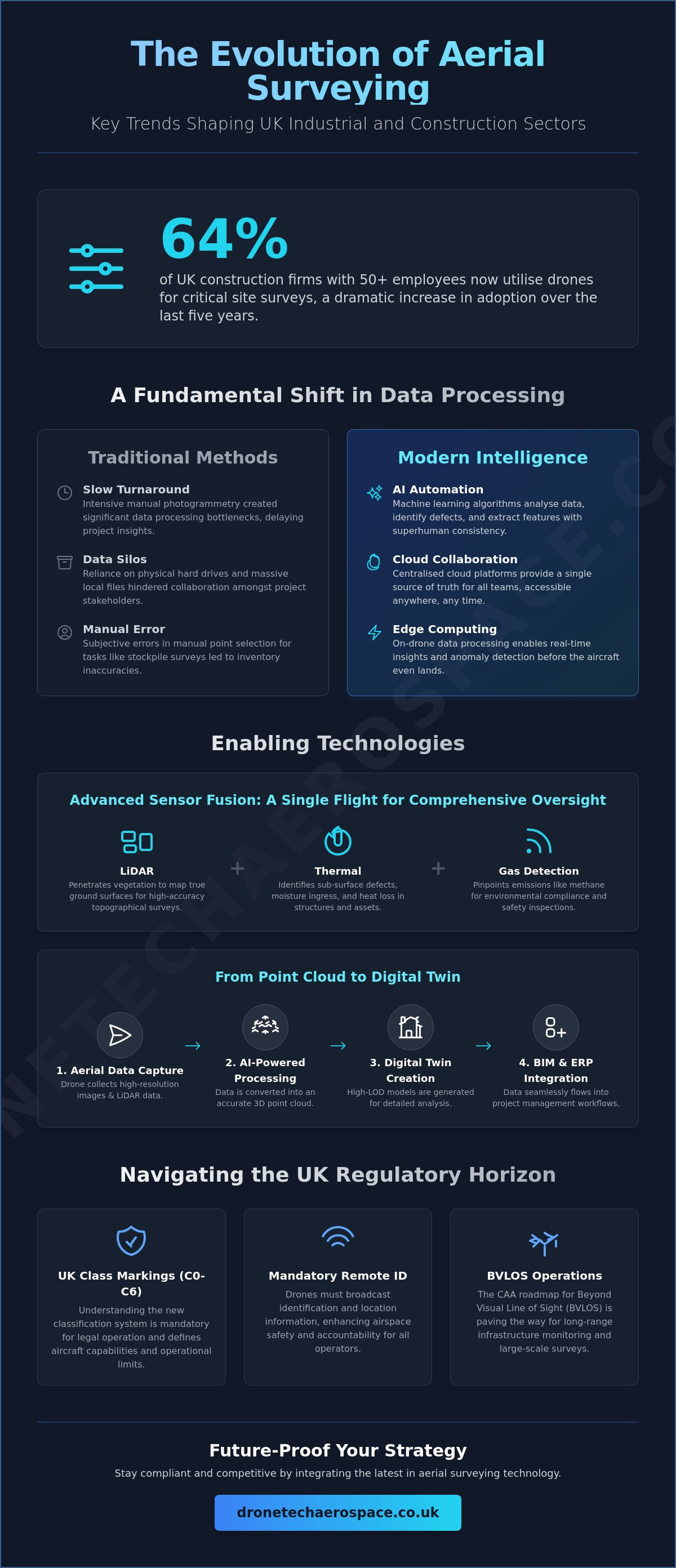
Whilst many viewed drones as a peripheral tool just five years ago, 64% of UK construction firms with 50 or more employees now utilise them for critical site surveys. This rapid adoption reflects a broader industrial shift where precision and speed are no longer optional. You likely understand the mounting pressure to reduce operational downtime and the frustration caused by data silos between aerial captures and BIM software. As the regulatory environment tightens, staying ahead of aerial surveying trends UK is essential for any high-capacity operation.
We promise to provide a clear technical roadmap that ensures your projects remain compliant and efficient through 2026 and beyond. You'll gain a comprehensive understanding of the latest UK class markings (UK0 to UK6), the mandatory Remote ID requirements, and the strategic integration of drone data into existing digital twin workflows. This guide delivers the industrial foresight required to navigate the transition from simple data collection to a real-time, AI-driven analytical ecosystem.
Key Takeaways
Learn how AI-driven automated intelligence and edge computing are significantly reducing data turnaround times for complex industrial inspections.
Explore the integration of high-accuracy LiDAR and methane detection sensors to achieve comprehensive site oversight within a single flight mission.
Understand the evolving aerial surveying trends UK that enable the seamless transition of aerial point clouds into sophisticated 3D digital twins and BIM workflows.
Gain critical insights into the CAA regulatory roadmap for BVLOS operations to prepare for the next generation of long-range infrastructure monitoring.
Identify the technical requirements for high-LOD 3D models to ensure absolute precision in heritage, industrial, and residential property management.
Table of Contents
The Evolution of Data Processing: From Images to Automated Intelligence
Conventional aerial survey methodologies traditionally relied on intensive manual photogrammetry; however, the sector is undergoing a profound transformation. Modern industrial data processing has moved beyond simple image capture toward automated intelligence. This shift is a cornerstone of current aerial surveying trends UK, where the focus has transitioned from delivering raw files to providing immediate, high-fidelity insights. The requirement for rapid delivery in the construction and energy sectors has made manual processing a bottleneck that modern AI-driven systems have now eliminated.
Turnaround times are being drastically reduced through edge computing. By processing data directly on the drone's hardware during flight, preliminary maps can be generated or critical anomalies identified before the aircraft even lands. This capability is vital for high-stakes environments (such as live wind turbine inspections or emergency infrastructure assessments) where delayed data can lead to increased operational risk. The move toward real-time processing represents a significant departure from the standard market offerings of the past decade.
Automated change detection allows for the precise comparison of site conditions over time. By overlaying sequential surveys, machine learning algorithms highlight deviations from project plans with extreme precision. This historical data also fuels predictive analytics. We can now forecast structural fatigue or soil erosion by analysing subtle shifts in topographic patterns over months or years. It's a proactive approach that ensures long-term asset integrity for industrial clients.
Artificial Intelligence in Feature Extraction
Machine learning algorithms now perform the heavy lifting in asset inspection. These systems are trained to identify specific defects (such as hairline fractures in concrete or corrosion on steel lattice towers) with a level of consistency that exceeds human capability. In the context of drone stockpile volume surveys, AI-powered extraction ensures that material boundaries are defined with absolute precision, eliminating the subjective errors inherent in manual point selection. This rigour is essential for maintaining accurate inventory records in heavy industry and civil engineering. These advancements in aerial surveying trends UK ensure that topographical data is both reliable and repeatable across multiple site visits.
Cloud-Based Collaboration and Data Accessibility
The era of shipping physical hard drives or managing massive local files is over. Centralised cloud platforms now allow multi-stakeholder access amongst remote teams, ensuring that project managers, engineers, and site supervisors all work from a single source of truth. Modern browser-based 3D visualisation tools enable users to interact with complex point clouds and high-LOD models without specialised hardware or software installations. Integrating these aerial insights directly into enterprise resource planning (ERP) systems ensures that data flows seamlessly into broader corporate workflows, enhancing professional accountability and streamlining project management for large-scale developments.
Advanced Sensor Fusion: LiDAR, Thermal, and Methane Detection
The integration of multiple high-fidelity sensors onto a single aerial platform has redefined the scope of industrial inspections. We are seeing a fundamental shift in aerial surveying trends UK toward multi-sensor payloads that capture RGB, LiDAR, and thermal data simultaneously. This synchronised approach eliminates the need for redundant flights; it ensures that every data point is spatially and temporally aligned across different spectra. For complex assets, our Drone Industrial Site Inspections & Surveys leverage these fused datasets to provide absolute professional assurance.
LiDAR technology has achieved a level of commoditisation that makes it accessible for large-scale topographical land surveys. Its primary advantage remains the ability to penetrate dense vegetation to map the true ground surface, a task where traditional photogrammetry often fails. Thermal imaging has also evolved beyond its basic origins. It is no longer restricted to identifying heat loss in buildings; it is now utilised for detecting sub-surface defects in industrial composites and concrete structures. By identifying thermal anomalies that indicate internal delamination or moisture ingress, we provide a level of foresight that standard visual inspections cannot match.
Specialised gas sensing represents a critical advancement in environmental compliance. Drone fugitive methane gas surveys are now essential for the energy sector, particularly following the implementation of the EUMR 2024/1787 regulation. These sensors allow for the precise localisation of leaks across vast pipeline networks or landfill sites without exposing personnel to hazardous environments. This remote sensing capability is a core component of the UK Civil Aviation Authority BVLOS roadmap, as long-range autonomous detection becomes the standard for linear infrastructure monitoring.
LiDAR vs Photogrammetry in 2026
Choosing between LiDAR and photogrammetry depends on the specific requirements of the project. Civil engineering projects often demand the millimetre-level precision that only high-density LiDAR point clouds can provide. Whilst photogrammetry remains cost-effective for open-site stockpile volume surveys, LiDAR is the superior choice for heritage site preservation where intricate structural details must be captured through overhanging foliage. The ability to generate a "bare earth" model regardless of ground cover is a decisive factor for many UK-based land surveys.
Environmental Compliance and Gas Detection
Meeting UK Net Zero targets requires rigorous and regular emission audits. Drones equipped with optical gas imaging (OGI) sensors provide a quantifiable method for monitoring methane emissions across industrial landscapes. This proactive approach identifies fugitive gases that would otherwise remain undetected, reducing both environmental impact and financial loss. By deploying these systems, operators significantly reduce the risk to personnel who would otherwise be required to perform manual inspections in potentially explosive or toxic zones.
The BIM Revolution: Integrating Aerial Data into Digital Twins
The shift from static imagery to dynamic Building Information Modelling (BIM) represents a pivotal advancement in aerial surveying trends UK. It's no longer sufficient to provide disparate data sets; the industry now demands seamless integration between aerial point clouds and existing architectural workflows. This evolution allows project managers to bridge the gap between physical site conditions and digital design intent, creating a unified environment for decision-making. High-LOD (Level of Detail) 3D models have become the baseline requirement for sophisticated UK property management, enabling owners to digitise vast portfolios for more efficient facility oversight.
Digital twins serve as living replicas of industrial assets, providing a platform for preventative maintenance that was previously impossible. Guided by the 2018 Gemini Principles, these digital models ensure that data remains purposeful, trustworthy, and functional throughout the asset lifecycle. By capturing high-fidelity data through an Advanced Drone Building Survey, operators can monitor structural health with granular detail. These models don't just represent the current state; they allow for the simulation of future scenarios, ensuring that maintenance schedules are based on empirical data rather than arbitrary timelines.
Achieving LOD 300 Standards with Drone Data
Translating raw drone data into BIM-ready components requires strict adherence to technical protocols. To reach LOD 300, elements must be graphically represented as specific systems, including accurate quantity, size, and orientation. Achieving this level of detail necessitates extreme geodetic accuracy, often verified through ground control points (GCPs). For a deeper dive into these requirements, refer to our Drone Survey 3D Model LOD: A Technical Guide to Level of Detail Standards. All operations must strictly follow the CAA guidance on Unmanned Aircraft Systems to ensure professional accountability and regulatory safety.
Asset Integrity and Preventative Maintenance
Industrial assets like chimneys and cooling towers require constant monitoring to prevent catastrophic failure. Using 3D models allows engineers to track structural changes, such as verticality shifts or surface degradation, over extended periods. This methodical approach to monitoring is a defining feature of current aerial surveying trends UK within heavy industry. This data is invaluable for insurance risk assessment and loss adjusting, providing a clear audit trail of asset condition. Implementing a robust Industrial Drone Inspection Strategy ensures that these high-stakes environments are managed with the precision required by the energy and construction sectors.
UK Regulatory Landscape: BVLOS and the Future of Operations
The UK regulatory framework is currently undergoing its most significant evolution since the inception of commercial drone flight. Central to these aerial surveying trends UK is the Civil Aviation Authority (CAA) roadmap, which aims to establish routine Beyond Visual Line of Sight (BVLOS) operations by 2027. This shift is facilitated by the UK SORA (Specific Operations Risk Assessment) framework, which replaced the previous OSC route on 23 April 2025. By standardising risk assessment, SORA allows for more predictable approvals for complex missions, particularly those involving linear infrastructure such as pipelines and railways. These operations no longer require the pilot to maintain a direct line of sight, allowing for vast distances to be covered in a single deployment.
As airspace modernisation continues under the Airspace Modernisation Strategy (AMS) toward 2040, the integration of Remotely Piloted Aircraft Systems (RPAS) into congested UK airspace is becoming a reality. The policy framework established in CAP2533 provides the necessary structure for testing and developing these advanced operations. For industrial clients, this means a transition toward higher levels of automation and the ability to conduct long-range surveys that were previously restricted. This increased capability ensures that data collection for large-scale infrastructure remains both efficient and professionally audited.
Navigating CAA Compliance for Large-Scale Projects
Industrial projects require a rigorous approach to compliance that extends beyond basic flight permissions. Hiring GVC-qualified (General Visual Line of Sight Certificate) pilots is essential for maintaining professional accountability on complex sites. This expertise is particularly critical when mitigating risk in urban environments for Residential Property Drone Inspections, where proximity to uninvolved persons is a primary safety concern. Additionally, operators must account for the 1 January 2026 mandate requiring UK class marks (UK0 to UK6) for all new drones, alongside mandatory Remote ID for UK-marked aircraft. Future-proofing your strategy requires an immediate transition to these compliant platforms to avoid operational grounding in 2026.
Remote Operations and Drone-in-a-Box Solutions
The emergence of automated docking stations, often termed "Drone-in-a-Box" solutions, facilitates persistent site monitoring without the need for constant on-site personnel. These systems allow drones to execute pre-programmed missions, providing continuous oversight for construction site monitoring and inspections. This remote deployment model significantly reduces the carbon footprint of surveying by eliminating the need for frequent travel to remote locations. Legal considerations for autonomous drone flights on UK industrial sites remain strict; however, the UK SORA framework provides a clear pathway for companies to demonstrate the safety and reliability of these persistent monitoring systems.
Future-Proofing Your Strategy with Drone Tech Aerospace
Drone Tech Aerospace operates at a distinct level of technical proficiency, leveraging over a decade of experience in executing complex UK aerial surveys. As industrial requirements move toward the sophisticated aerial surveying trends UK outlined in this guide, the necessity for a high-capacity partner becomes evident. We provide the professional assurance that your large-scale requirements will be handled with absolute precision and accountability. Our proprietary methods have evolved alongside the industry, ensuring we remain a seasoned veteran in a rapidly changing technological landscape.
The 2026 landscape demands more than standard data collection. It requires a partner that understands the nuances of UK SORA frameworks and the technicalities of high-LOD digital twins. We position ourselves as a high-performance partner, delivering bespoke systems that are tailored to the rigorous standards of the civil engineering and heavy industry sectors. Reliability is the cornerstone of our operations; we ensure that every data point captured is actionable, accurate, and professionally audited.
Bespoke Solutions for Challenging Environments
Navigating high-stakes environments requires specialised equipment and a proven track record in demanding conditions. We utilise ball/cage-drone technology to perform Internal & Confined Space Inspections, allowing for the visual assessment of assets without exposing personnel to hazardous conditions. In the renewable energy sector, our Solar-farm and Wind Turbine Drone Inspections provide the granular data necessary for comprehensive integrity audits and preventative maintenance. These technical solutions are designed to reduce operational downtime whilst maintaining the highest levels of professional accountability across the UK construction and energy sectors. You may contact our team for a technical consultation on your next project to discuss how our bespoke systems can be integrated into your specific industrial workflow.
Summary of 2026 Strategic Recommendations
To maintain a competitive advantage and ensure regulatory compliance, we recommend the following strategic actions for industrial and construction stakeholders:
Prioritise Data Integration: Move beyond simple image capture by ensuring all aerial data is BIM-ready and compatible with existing ERP systems.
Adopt Multi-Sensor Payloads: Invest in surveys that combine LiDAR, thermal, and RGB data to gain a comprehensive understanding of asset health in a single mission.
Verify Regulatory Compliance: Ensure all service providers are fully compliant with the 2026 UK class markings and have transitioned to the UK SORA risk assessment framework.
Engage Specialist Expertise: Partner with established organisations that possess the technical prowess to navigate the complexities of BVLOS and automated site monitoring.
The trajectory of aerial surveying trends UK suggests that those who invest in high-fidelity data and rigorous compliance today will be best positioned to lead the industrial landscape of tomorrow. Precision is not merely a goal; it's the standard by which all future projects will be measured.
Securing Industrial Precision in a Digital-First Era
The industrial landscape is moving toward a future where data is not merely captured but intelligently integrated into every phase of the project lifecycle. Navigating the current aerial surveying trends UK requires a shift from reactive monitoring to proactive, AI-driven analysis. Success in 2026 doesn't just depend on adoption; it requires the seamless integration of advanced sensor fusion and high-LOD digital twins whilst ensuring absolute compliance with evolving CAA regulations.
We provide the technical prowess and operational scale required to manage these complex transitions. With over 10 years of industrial experience and a team of UK CAA GVC qualified pilots, we deliver results that smaller competitors cannot match. Our deployment of specialised confined space cage-drone technology ensures that even the most hazardous environments are surveyed with precision and safety. This methodical approach guarantees that your data is both actionable and professionally audited.
Ensure your assets are managed with professional accountability and technical rigour. Contact Drone Tech Aerospace for a Professional Aerial Survey Consultation today. We look forward to securing the future of your industrial data.
Frequently Asked Questions
What are the most significant aerial surveying trends in the UK for 2026?
The most significant aerial surveying trends UK for 2026 include the mandatory implementation of Remote ID, the transition to the UK SORA risk assessment framework, and the widespread adoption of multi-sensor fusion. These shifts move the industry toward routine Beyond Visual Line of Sight (BVLOS) operations. Industrial sectors are also prioritising AI-powered automated feature extraction to replace manual data processing, ensuring faster turnaround times and higher professional accountability.
How is LiDAR technology changing the landscape of UK land surveys?
LiDAR technology allows for precise topographical mapping by penetrating dense vegetation to capture the true ground surface. This capability is essential for civil engineering and large-scale land surveys where traditional photogrammetry cannot provide accurate "bare earth" models. Modern LiDAR sensors now deliver millimetre-level precision, enabling the creation of high-density point clouds that serve as the foundation for complex infrastructure design and heritage preservation projects.
What does BVLOS mean for the future of UK drone inspections?
BVLOS (Beyond Visual Line of Sight) refers to drone operations conducted at distances where the pilot cannot maintain a direct visual link with the aircraft. This capability is revolutionary for linear infrastructure surveys, such as railways and pipelines, as it allows for vast distances to be covered in a single flight. The CAA roadmap aims for routine BVLOS operations by 2027, significantly reducing the logistical costs and time required for large-scale industrial inspections.
Can drone survey data be directly integrated into BIM software?
Drone survey data is directly integrated into Building Information Modelling (BIM) software through the generation of georeferenced point clouds and 3D mesh models. This allows project managers to overlay current site conditions with architectural designs to identify discrepancies immediately. To ensure professional standards, this data must meet specific Level of Detail (LOD) requirements, such as LOD 300, which provides the precise geometric information needed for facility management and construction monitoring.
How are drones being used for methane leak detection in the UK?
Drones utilise specialised optical gas imaging (OGI) sensors to detect fugitive methane emissions across vast industrial landscapes and energy facilities. This technology allows operators to meet the stringent requirements of the EUMR 2024/1787 regulation by localising leaks with absolute precision. By deploying these sensors, companies can perform regular emission audits without exposing personnel to hazardous environments, supporting UK Net Zero targets through proactive environmental compliance.
What is the role of AI in processing aerial survey data?
AI plays a critical role in automating the extraction of meaningful features from raw aerial datasets, such as identifying structural defects or calculating stockpile volumes. Machine learning algorithms process thousands of images to detect hairline fractures, corrosion, or anomalies that a human eye might overlook. This automation eliminates subjective error and significantly reduces processing times, allowing for predictive analytics that forecast structural fatigue or erosion based on historical survey data.
Are there specific UK regulations for drone surveys on heritage sites?
Surveys on UK heritage sites must comply with standard CAA regulations (CAP 722) whilst adhering to specific non-invasive data collection protocols. Operators must ensure that drone activities do not disturb sensitive structures or violate local planning constraints. The use of high-accuracy LiDAR is often preferred in these environments to map historical features through overhanging foliage without physical contact, providing a detailed digital record that supports long-term conservation and restoration efforts.
How do I choose a professional drone survey provider in the UK?
Selecting a professional provider requires verifying their technical credentials, including UK CAA GVC qualifications and a proven track record in your specific industrial sector. A high-performance partner should demonstrate expertise in complex aerial surveying trends UK, such as BVLOS readiness and BIM integration. It's essential to assess their equipment capability (such as internal ball-drones or methane sensors) and ensure they carry comprehensive professional indemnity and public liability insurance for high-stakes environments.


Comments