
Remote Methane Sensing Safety: Dispelling Industrial Gas Detection Myths
- John Palmer (Director, DTA)

- 7 days ago
- 12 min read
Sending a technician into a high-risk zone with a hand-held sensor is no longer the gold standard of industrial protection; it is an unnecessary operational liability. Whilst the industry has historically relied on manual sniffer-probe inspections, the 2026 regulatory landscape, including the full enforcement of EU Methane Regulation (2024/1787) and US EPA Subpart OOOOb/c, now demands a more sophisticated approach. You likely recognise the escalating difficulty of quantifying fugitive emissions accurately whilst managing the inherent safety risks of personnel in hazardous zones.
This article clarifies the technical reality of remote methane sensing safety, demonstrating how aerial technology surpasses traditional manual inspection standards in both precision and personnel protection. We will provide evidence that UAV-based detection achieves the 95% accuracy required for modern compliance (utilising specialised AI-powered analytics) and offer a structured framework for integrating these remote systems into your existing safety protocols. This analysis serves to reassure industrial operators that their complex, large-scale requirements can be handled with absolute precision and professional accountability.
Key Takeaways
Recognise why manual sniffer-probe inspections represent an unnecessary operational risk under the stringent 2026 global methane regulations.
Identify the precision capabilities of Tunable Diode Laser Absorption Spectroscopy (TDLAS), which provides accurate ppm-level data without requiring physical contact.
Quantify the safety benefits of remote methane sensing safety by calculating the reduction in Man-Hours in Hazardous Zones (MHHZ) for your facility.
Deconstruct the myths surrounding ignition risks by understanding how professional UAV operations maintain safe standoff distances from ATEX-classified zones.
Establish a superior safety protocol through the integration of high-resolution Optical Gas Imaging (OGI) and spectroscopic data for audit-ready compliance.
Table of Contents
The Evolution of Methane Detection: Why Manual Inspection is No Longer the Safety Gold Standard
Deconstructing the 'Accuracy Myth' in Remote Spectroscopic Sensing
Safety ROI: How Remote Sensing Eliminates High-Risk Human Exposure
Operational Safety: Navigating ATEX Zones and Aerial Flight Risks
Professional Aerial Methane Surveys: The Drone Tech Aerospace Standard
The Evolution of Methane Detection: Why Manual Inspection is No Longer the Safety Gold Standard
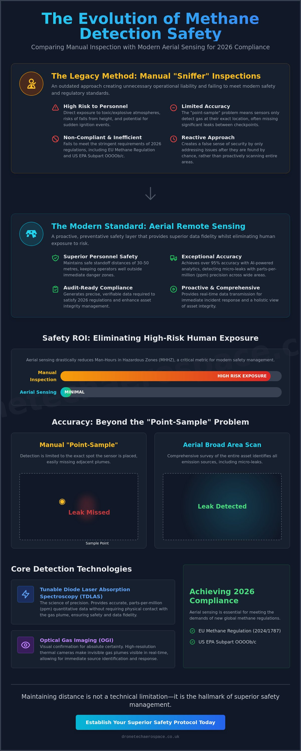
Remote methane sensing is defined as the non-contact detection of gas plumes using advanced spectroscopic or laser-based technology. Unlike traditional methods that require a physical presence within a potentially explosive atmosphere, this approach utilises light absorption to identify methane concentrations from a distance. The UK energy sector has historically relied on manual "sniffing" techniques, where technicians traverse hazardous zones with hand-held sensors. This legacy approach was born from a period where portable, high-sensitivity sensors were unavailable, forcing operators to accept high levels of human risk as a standard cost of business. However, the industry is now undergoing a fundamental shift toward proactive aerial visualisation. This transition is driven by a need to eliminate the "Boots on the Ground" myth, which incorrectly suggests that physical proximity to a leak is necessary for accurate quantification. In 2026, maintaining distance is not a sign of technical limitation but a hallmark of superior safety management. Various Methane leak detection methods have evolved, yet aerial remote sensing remains the most effective way to protect personnel whilst ensuring regulatory compliance.
The Limitations of Traditional Sniffer Probes
Manual sniffer probes present significant operational risks. Personnel are frequently exposed to toxic or explosive atmospheres during routine checks, particularly when investigating suspected leaks in confined spaces or elevated infrastructure. Traditional probes suffer from the "point-sample" problem. They only detect gas at the exact location of the sensor head, often missing significant leaks that occur between manual check-points. This reactive approach creates a false sense of security whilst leaving personnel vulnerable to sudden ignition events or asphyxiation. Accessing elevated pipe racks or flare stacks manually also introduces the risk of falls from height, a danger that is entirely avoided through aerial deployment.
Remote Sensing as a Preventative Safety Layer
Remote sensing acts as a critical preventative safety layer by establishing significant standoff distances between the surveying team and the hazard. Professional drone systems typically operate at heights or horizontal distances of 30 to 50 metres, well outside the immediate danger zone. This standoff capability ensures that even in the event of a major structural failure or high-pressure release, the operators remain safe. Real-time data transmission allows for immediate incident response, providing site managers with instantaneous visual and quantitative evidence of a leak's severity. Integrating these capabilities into a broader industrial drone inspection strategy ensures that methane detection is not an isolated task but a core component of holistic asset integrity management. By prioritising remote methane sensing safety, industrial facilities can drastically reduce their Man-Hours in Hazardous Zones (MHHZ) without compromising on the fidelity of their environmental reporting.
Deconstructing the 'Accuracy Myth' in Remote Spectroscopic Sensing
A common misconception amongst industrial safety managers is that remote sensors are inherently less sensitive than traditional hand-held sniffer devices. This "Accuracy Myth" stems from a misunderstanding of how light-based detection operates compared to chemical-reaction-based point sensors. In reality, modern aerial systems provide parts-per-million (ppm) level precision that matches or exceeds manual equipment whilst providing a broader field of view. This capability is central to remote methane sensing safety, as it allows for the identification of micro-leaks that might be missed by a technician walking a predetermined, linear path. By removing the requirement for physical contact with the gas plume, we ensure that accuracy is achieved without compromising the safety of the surveying personnel.
TDLAS: The Science of Laser-Based Safety
Tunable Diode Laser Absorption Spectroscopy (TDLAS) targets the specific methane absorption lines found between 1.65μm and 1.67μm. Because this wavelength is unique to the methane molecule, laser-based sensing is virtually immune to cross-gas interference from other hydrocarbons or water vapour. TDLAS is a method of measuring gas concentration by calculating laser light attenuation across a known path. This technical precision ensures that safety alarms are only triggered by genuine methane threats, reducing the operational downtime associated with false positives. Adhering to rigorous federal methane monitoring safety standards, our systems ensure that data integrity is maintained even in complex industrial environments where high-pressure equipment and varying temperatures are present.
Quantification vs. Detection
Effective safety protocols must move beyond simple binary detection. Knowing a leak exists is insufficient; operators must understand the mass-flow rate to prioritise repairs based on explosive risk and environmental impact. Aerial systems utilise advanced algorithms to calculate these rates in real-time, providing a quantitative basis for emergency response decisions. For a deeper technical analysis of these methodologies, consult our aerial methane quantification guide. This transition from "is there a leak" to "how dangerous is the leak" is fundamental to modern risk management.
Optical Gas Imaging (OGI) complements laser-based data by turning invisible hazards into actionable visual data. Whilst TDLAS provides the numerical concentration, OGI provides the visual context, allowing engineers to see the plume's movement relative to ignition sources. Atmospheric correction factors, including wind speed and ambient temperature, are integrated into the data processing to ensure the final report reflects the actual site conditions. This multi-layered approach provides a level of assurance that manual inspections simply cannot match. If your facility requires this level of technical oversight, our Drone Fugitive Methane Gas Surveys provide the comprehensive data needed to enhance your current safety regime.
Safety ROI: How Remote Sensing Eliminates High-Risk Human Exposure
Remote sensing is frequently mischaracterised as a "luxury technology" or an expensive supplementary service. This perspective fails to account for the fundamental shift in safety ROI that occurs when personnel are removed from the immediate vicinity of volatile assets. Under the stringent 2026 regulatory framework, remote methane sensing safety is a core operational requirement rather than an optional extra. It represents a strategic investment in risk mitigation that transforms gas detection from a high-stakes manual task into a controlled, remote operation. By treating aerial sensing as a primary safety tool, industrial operators can achieve a level of site-wide surveillance that was previously cost-prohibitive or physically impossible.
The primary metric for evaluating this technology is the reduction of Man-Hours in Hazardous Zones (MHHZ). Traditional leak detection requires technicians to spend hundreds of hours per year navigating ATEX-classified areas, often in close proximity to high-pressure infrastructure. Aerial deployment allows for a total withdrawal of personnel from these zones during the initial survey phase. Beyond the gas exposure itself, remote sensing drastically reduces the requirement for high-risk ancillary activities. This includes the erection of complex scaffolding, the operation of Mobile Elevating Work Platforms (MEWPs), or the deployment of rope access teams to inspect elevated pipe racks. Eliminating these secondary risks provides a substantial and quantifiable improvement to the overall site safety profile.
Comparison: Manual vs. Remote Aerial Inspection
The operational disparity between manual and aerial methods is significant, particularly regarding speed and personnel risk. Whilst manual technicians are typically limited to covering 2-3km of infrastructure per day, professional UAV systems regularly achieve 20-30km per day. This tenfold increase in site coverage does not come at the expense of data quality; rather, it provides a superior audit trail for Health and Safety Executive (HSE) compliance. Aerial data is repeatable, timestamped, and geofenced, ensuring that every square metre of a facility is accounted for without putting a single person at risk.
Mitigating the Risk of Major Incident Events
Proactive remote sensing allows for the identification of fugitive emissions long before they reach the Lower Explosive Limit (LEL). By detecting micro-leaks early, facilities can prevent the escalation of minor faults into catastrophic ignition events. This is particularly critical for identifying "super-emitters" (large-scale leaks that account for a disproportionate percentage of total site emissions and pose the highest immediate safety risk). In the event of a structural failure, remote sensing plays a vital role in disaster recovery and post-incident site assessment. It allows emergency responders to visualise gas plumes and identify safe entry points without entering the hazard zone blindly.
Operational Safety: Navigating ATEX Zones and Aerial Flight Risks
A persistent myth suggests that drones represent an inherent ignition risk in gas-rich environments. This concern often stems from a lack of clarity regarding how remote methane sensing safety protocols are structured. In professional operations, UAVs don't enter the explosive atmosphere; they operate in "Safe Zones" located vertically or horizontally away from the plume. The 6th Edition of the ATEX 2014/34/EU Guidelines (released in January 2026) provides clearer interpretation for operators, whilst the UK's designated standards for explosion-protected equipment (updated on March 18, 2026) reinforce the necessity of rigorous standoff distances. By maintaining these distances, aerial systems eliminate the need for explosion-proof hardware on the aircraft itself, as the platform remains outside the classified hazardous volume.
ATEX Zoning and UAV Deployment
Zone 0: An area where an explosive atmosphere is present continuously or for long periods (typically internal to vessels or pipes).
Zone 1: An area where an explosive atmosphere is likely to occur in normal operation occasionally.
Zone 2: An area where an explosive atmosphere is not likely to occur in normal operation but, if it does, will persist for a short period only.
The safety of aerial methane sensing relies on the inverse square law of gas dispersion and precise standoff distance maintenance. Because methane is lighter than air, it disperses rapidly as it rises and mixes with the atmosphere. Professional flight teams utilise real-time telemetry to ensure the aircraft never breaches the calculated Zone 2 boundary. This methodology ensures that the drone serves as a high-performance partner in site safety, rather than a potential ignition source.
UK Flight Safety Standards for Industrial Sites
Operating near high-pressure pipelines or complex refineries requires more than standard pilot certification. Every industrial mission is governed by a strict Operational Safety Case (OSC) approved by the Civil Aviation Authority (CAA). These safety cases account for site-specific risks, including electromagnetic interference (EMI) from large-scale industrial plant and high-voltage infrastructure. To ensure reliability, industrial-grade drones employ multi-sensor redundancy (including dual IMUs and triple-redundant GNSS systems) to prevent flight controller failure. Emergency failsafe protocols, such as automated "Return to Home" (RTH) on signal loss or low battery, are standard requirements for all Drone Industrial Site Inspections & Surveys. This level of technical prowess ensures that the survey is conducted with absolute precision and professional accountability.
Professional Aerial Methane Surveys: The Drone Tech Aerospace Standard
The transition to aerial detection requires more than just the deployment of hardware; it necessitates a sophisticated operational framework that prioritises professional accountability over standard market offerings. Whilst many providers offer basic visual inspections, our bespoke approach integrates high-resolution Optical Gas Imaging (OGI) and spectroscopic TDLAS data into a single, cohesive safety intelligence report. This dual-sensor integration ensures that remote methane sensing safety is not merely a theoretical advantage but a functional reality for our clients. By combining visual plume evidence with quantitative mass-flow data, we provide a level of site-wide surveillance that distinguishes our professional-grade services from amateur or consumer-level solutions.
Technical Leadership in Remote Sensing
Our operational superiority is grounded in ten years of experience navigating the complexities of UK industrial sites, from high-pressure pipeline networks to large-scale chemical refineries. We have developed proprietary data processing workflows that translate raw sensor readings into clear, actionable intelligence for safety and maintenance teams. These reports identify specific leak coordinates, estimated flow rates, and plume behaviour, allowing for surgical repair interventions that minimise operational downtime. We avoid "off-the-shelf" reporting tools in favour of bespoke systems that meet the rigorous standards of the Health and Safety Executive (HSE) and UK environmental regulators. This commitment to technical leadership ensures that every survey provides a robust, audit-ready data set for corporate compliance.
Strategic Partnership for Safety Integrity
We don't operate as a mere service vendor; we function as a high-performance partner for industrial operators. Our consultative approach involves a comprehensive site-specific risk assessment before any flight commences, ensuring that our sensor configurations are optimised for the target asset. This long-term focus supports our clients' wider Environmental, Social, and Governance (ESG) reporting requirements, providing the precise data needed to meet the 2026 methane reduction targets. By integrating remote sensing into existing safety protocols, we help facilities evolve beyond reactive maintenance into a proactive regime of asset integrity. Contact our technical team to discuss your methane sensing safety requirements and learn how our seasoned expertise can secure your facility against fugitive emissions.
Advancing Industrial Safety Through Aerial Technical Prowess
The transition from legacy manual sniffer probes to aerial detection represents a significant advancement in industrial risk management. By eliminating the requirement for personnel to enter hazardous zones, operators can drastically reduce their Man-Hours in Hazardous Zones (MHHZ) whilst maintaining ppm-level accuracy. The technical reality of remote methane sensing safety ensures that facilities remain compliant with the latest HSE and environmental regulations without the operational downtime associated with traditional methods.
Our team brings over 10 years of industrial drone expertise to every mission, utilising CAA-certified pilots to navigate high-risk environments with absolute precision. We provide bespoke reporting designed specifically for HSE and ESG compliance, ensuring that your data is both actionable and audit-ready. This professional-grade approach transforms gas detection from a liability into a core component of site integrity.
Enquire about our professional Drone Fugitive Methane Gas Surveys to secure your facility's operational integrity. We look forward to establishing a high-performance partnership that prioritises your site's safety and regulatory success.
Frequently Asked Questions
Is remote methane sensing as accurate as hand-held sniffer probes?
Remote spectroscopic sensors provide ppm-level (parts-per-million) accuracy that matches or exceeds traditional hand-held sniffer probes. Whilst manual probes require physical contact with a gas plume, remote systems utilise laser absorption to quantify concentrations from a distance. This non-contact approach eliminates the "point-sample" error often found in manual checks, where a technician might walk past a leak that is slightly out of reach or located in an inaccessible area.
Can drones safely operate in ATEX-rated hazardous areas?
Industrial UAVs typically operate in "Safe Zones" outside of classified ATEX boundaries by maintaining strict vertical and horizontal standoff distances. By remaining in the non-hazardous atmosphere above or away from a leak, the aircraft doesn't require explosion-proof certification. Professional pilots utilise real-time telemetry to ensure the drone never breaches Zone 2 boundaries, adhering to the updated 2026 UK standards for explosion-protected equipment.
What is the maximum distance a remote sensor can detect a methane leak?
The effective detection range for professional remote sensors typically spans between 30 and 100 metres, depending on the specific payload and atmospheric conditions. Laser-based systems (TDLAS) can identify methane plumes from significant altitudes, whilst Optical Gas Imaging (OGI) cameras provide visual confirmation from similar standoff distances. This range is sufficient to keep the aircraft and personnel well away from high-pressure release points or potentially explosive concentrations.
How does remote methane sensing improve personnel safety on industrial sites?
Personnel safety is fundamentally improved by reducing the Man-Hours in Hazardous Zones (MHHZ) to near zero during the survey phase. Technicians are no longer required to traverse high-risk areas, climb scaffolding, or use rope access to inspect elevated infrastructure. By prioritising remote methane sensing safety, site managers can plan repairs with precise coordinate data, ensuring that personnel only enter hazardous areas when a specific, quantified maintenance task is required.
What are the UK regulatory requirements for methane leak detection?
UK operators must comply with the Health and Safety at Work Act 1974 and the DSEAR 2002 regulations regarding explosive atmospheres. Additionally, the UK's designated standards for explosion-protected equipment (updated on March 18, 2026) and environmental reporting mandates require accurate quantification of fugitive emissions. Professional aerial surveys provide the necessary audit trails and geofenced data sets to satisfy both Health and Safety Executive (HSE) inspections and Environmental Agency (EA) compliance audits.
Does remote sensing work in adverse weather conditions like wind or rain?
Remote sensing is most effective in stable weather conditions, as heavy rain or dense fog can attenuate laser signals and reduce OGI thermal contrast. High wind speeds (typically exceeding 10-12 m/s) also disperse gas plumes too rapidly for accurate mass-flow quantification. Professional survey teams monitor meteorological data in real-time to ensure flights are only conducted within the technical parameters required for high-fidelity data capture and flight safety.
How long does a typical aerial methane survey take for a large industrial facility?
An aerial survey of a large industrial facility is significantly faster than manual methods, often covering 20 to 30 kilometres of pipeline or an entire refinery complex in two to three days. A site that might take a manual team weeks to inspect can be processed with high-fidelity data in a fraction of the time. This efficiency reduces the total time that survey equipment is on-site and allows for more frequent monitoring intervals.
What is the difference between TDLAS and OGI for methane detection?
TDLAS (Tunable Diode Laser Absorption Spectroscopy) is a quantitative tool used to measure exact methane concentrations in ppm-m, whilst OGI (Optical Gas Imaging) is a qualitative tool that visualises the gas plume as a "smoke-like" image. TDLAS provides the data required for mass-flow calculations and regulatory reporting. OGI provides the visual context needed to identify the exact point of failure and observe how the gas is dispersing across the site.


Comments