
Stockpile Survey Accuracy: A Technical Comparison of Modern Methodologies
- John Palmer (Director, DTA)
- Jun 8
- 12 min read
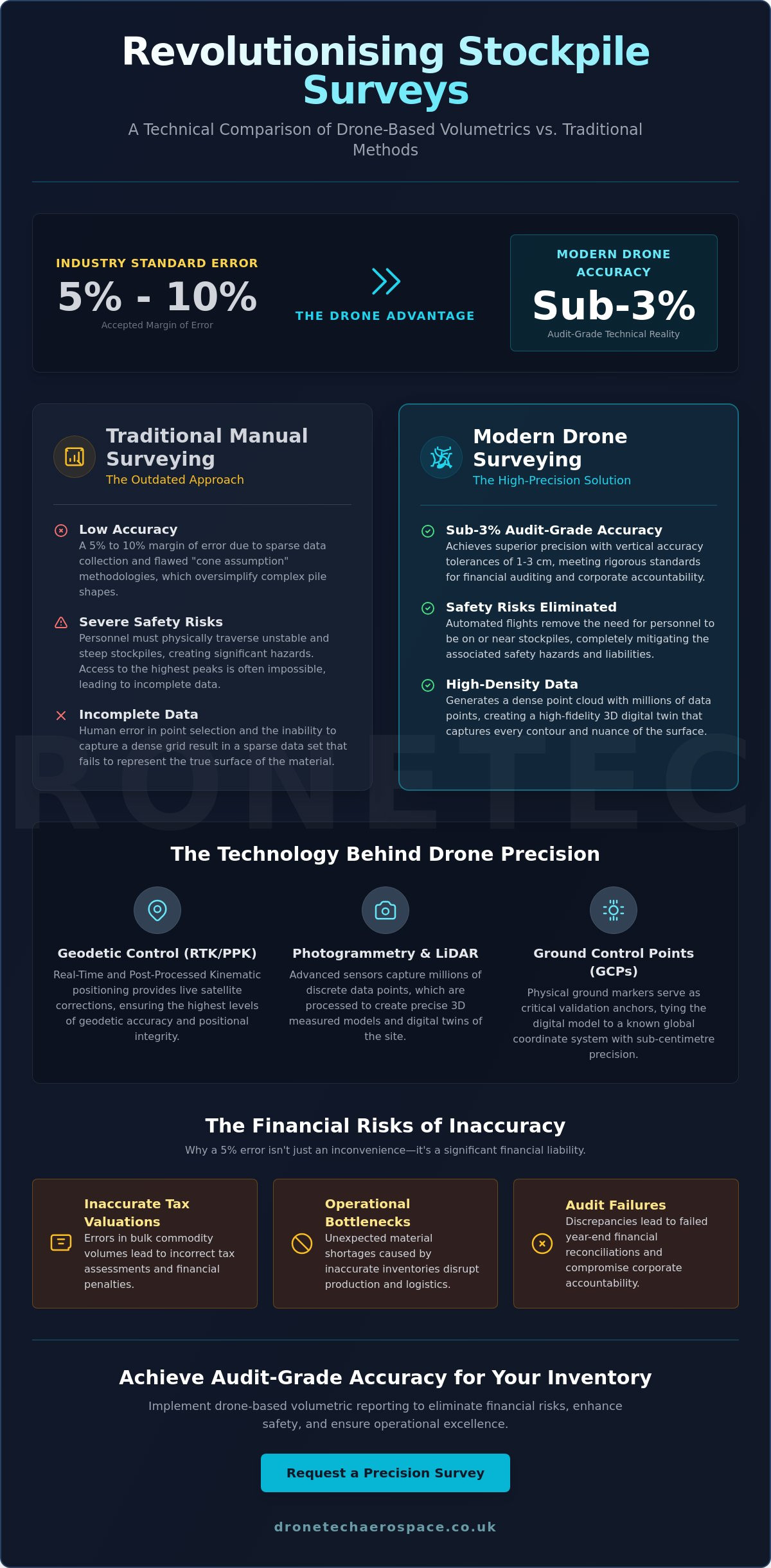
Whilst many site managers accept a 5% to 10% margin of error as an unavoidable industry standard, modern drone-based methodologies have proven that achieving a stockpile survey accuracy of sub-3% is now a repeatable technical reality. Managing large-scale bulk inventories presents persistent operational challenges, particularly regarding the safety risks of personnel traversing unstable material and the inherent delays of manual data collection. Industry professionals recognise that end-of-month discrepancies represent significant financial liabilities (requiring absolute precision for corporate accountability) rather than mere administrative inconveniences.
This technical comparison demonstrates how integrated drone systems (utilising RTK and PPK geodetic control) reduce inventory error margins to under 3% whilst simultaneously eliminating the safety risks associated with staff climbing large stockpiles. You will discover the specific methodologies required to obtain audit-grade volumetric reports with significantly faster turnaround times. We examine the performance benchmarks of drone photogrammetry versus traditional total station instruments (incorporating 2026 ALTA/NSPS Land Title Survey standards) to illustrate how modern technology delivers superior results for civil engineering and heavy industry applications. The analysis covers critical factors including geodetic control requirements, vertical accuracy tolerances (typically 1-3 cm), the integration of data into CAD and BIM platforms, and the specific application of 2026 standards to modern volumetric reporting.
Key Takeaways
Distinguish between relative and absolute precision to understand how volumetric measurements are calculated as a percentage of total volume.
Identify the technical criteria for selecting between Photogrammetry and LiDAR sensors based on specific material characteristics and site conditions.
Evaluate how drone-based methodologies achieve a stockpile survey accuracy of sub-3% compared to the inherent limitations and safety risks of traditional manual surveying.
Recognise the impact of atmospheric conditions and material "fluff factors" on data integrity to ensure audit-grade reporting.
Implement rigorous geodetic control and validation protocols to transform raw point cloud data into precise 3D measured models for inventory management.
Table of Contents
Defining Stockpile Survey Accuracy in 2026
Precision in inventory management is fundamentally dependent on the distinction between relative and absolute accuracy. Relative accuracy refers to the internal consistency of the measurement (the precision of points relative to each other within the model), whilst absolute accuracy defines the geodetic position of the data within a global coordinate system. In the context of industrial stockpile survey accuracy, achieving a ±1-3% margin of error is the established benchmark for audit-grade reporting. When data falls outside this tolerance, the resulting discrepancies in material reconciliation lead to significant balance sheet adjustments; these errors represent substantial risks for large-scale operations, including:
Inaccurate tax valuations for bulk commodities.
Operational bottlenecks caused by unexpected material shortages.
Audit failures during mandatory year-end financial reconciliations.
Volumetric precision is calculated as a percentage of total volume because absolute error values (measured in cubic metres) scale proportionally with the size of the stockpile. A high-capacity provider understands that a fixed error margin is insufficient; the methodology must scale with the site requirements to ensure financial accountability across millions of tonnes of material.
The Mathematical Reality of Volumetric Errors
High-capacity providers prioritise point cloud density to ensure the highest level of surface reconstruction. A seemingly minor 5cm vertical error, when projected across a 10-acre industrial site, results in massive volumetric deviations that compromise the integrity of the entire dataset. The application of photogrammetry principles allows for the capture of millions of discrete data points, ensuring that every contour and depression is recorded with absolute technical fidelity. Within the framework of RICS standards, volumetric accuracy is the measurable degree to which a digital model reflects the actual physical quantity of material present on a site.
Why Traditional "Walking" Methods Often Fail
Traditional manual surveying frequently relies on the "cone assumption," a methodology that treats irregular material piles as geometric primitives (simplifying complex, undulating shapes into basic cones or prisms). This approach is inherently flawed as it ignores the real-world irregularities of bulk materials. GNSS rovers require a surveyor to physically traverse the material, which presents severe safety risks (especially on unstable or steep peaks). Because staff cannot safely access the apex of many stockpiles, they often omit critical data from the highest sections. Human error in point selection, combined with the physical inability to capture a dense grid, leads to a sparse data set that fails to represent the true surface; it's this lack of density that results in inventory reports that fail to meet the precision required for modern industrial accountability and financial auditing.
The Mechanics of Precision: How Drones Calculate Volume
Achieving superior stockpile survey accuracy requires a sophisticated integration of hardware, geodetic control, and post-processing software. Unlike traditional stockpile measurement methods that rely on sparse point collection, drone-based systems generate dense datasets that capture every physical nuance of a material pile. The process begins with establishing geodetic control through Real-Time Kinematic (RTK) or Post-Processed Kinematic (PPK) positioning. RTK provides live corrections to the drone’s satellite data during flight, whilst PPK involves processing the data after the mission to ensure the highest levels of positional integrity, especially in environments where signal interference is a factor. Ground Control Points (GCPs) remain a critical requirement for absolute validation, serving as physical anchors that tie the digital model to a known global coordinate system with sub-centimetre precision.
Once the data is captured, advanced algorithms generate a 3D mesh, creating a high-fidelity digital twin of the material. This mesh allows for precise volumetric calculations that account for the irregular voids and peaks often missed by manual surveys. For organisations managing complex assets, these surveys are often incorporated into a wider industrial drone inspection strategy, ensuring that inventory data is synchronised with overall facility maintenance and monitoring requirements. This integrated approach provides a single source of truth for both operational and financial departments.
Photogrammetry: Turning Imagery into Coordinates
Photogrammetry relies on the mathematical principle of triangulation, where multiple overlapping images are used to determine the coordinates of points in 3D space. To maintain high standards of stockpile survey accuracy, we utilise a minimum overlap of 80/80 (80% forward and 80% side overlap) to ensure sufficient feature matching across the entire site. The Ground Sample Distance (GSD), which refers to the physical size of one pixel on the ground, dictates the final level of detail; a lower GSD results in higher resolution and more precise surface reconstruction. Challenges can arise with featureless materials, such as extremely bright sand or dark, uniform coal, where the software may struggle to identify unique tie points between images without high-contrast markers.
LiDAR: Penetrating Complexity
LiDAR (Light Detection and Ranging) provides an active sensing alternative that is often superior for complex material shapes or sites with difficult environmental conditions. Whilst photogrammetry is a passive system that requires external light and visual texture, LiDAR emits its own laser pulses to measure distances directly. This capability allows the sensor to penetrate vegetation or capture data in shadowed areas that would otherwise result in "noise" or gaps in a photogrammetric model. For industrial sites with significant dust or irregular material textures, LiDAR ensures a cleaner point cloud and more reliable volumetric results. Clients seeking to optimise their inventory workflows can explore our professional drone stockpile volume surveys to see how these sensors are deployed in high-stakes environments.
Comparative Analysis: Drone Volumetrics vs. Traditional Methods
The efficacy of stockpile survey accuracy is fundamentally determined by the density of the sampled data. Whilst Total Station measurements have historically been considered the "Gold Standard" for point-to-point precision, the practical application of this technology on active industrial sites is often compromised by severe time constraints and safety protocols. Surveyors using traditional methods are frequently restricted by the sheer physical scale of the material, leading to a reliance on sparse data sets that fail to capture the complex geometry of modern stockpiles. To assist in technical decision-making, the following table outlines the performance tiers of contemporary survey methodologies.
Data Density and Surface Fidelity
A manual survey typically relies on approximately 50 to 100 discrete points to define a stockpile surface. This sparse sampling creates "dead zones" where the software must interpolate between points, often leading to a significant overestimation of volume by smoothing over internal depressions. In contrast, aerial surveys capture upwards of 5 million points per mission. This level of detail ensures that the resulting Digital Elevation Models (DEMs) represent a true-to-life surface fidelity. The difference is mathematically profound. Dense point clouds eliminate the interpolation errors inherent in manual methods, ensuring that every cubic metre of material is accounted for with professional accountability.
Operational Speed and Site Safety
Data collection speed is a critical factor for large-scale inventory management. A manual survey of a 10-acre site can require several hours of intensive fieldwork; a drone completes the same task in under 20 minutes. This rapid turnaround enables more frequent inventory audits, allowing managers to maintain tighter control over material reconciliation throughout the month. Beyond efficiency, the primary advantage is the total elimination of "working at height" risks. Survey personnel are no longer required to climb unstable piles of aggregate, coal, or ore. By removing staff from the hazardous material surface, organisations maintain the highest safety standards whilst simultaneously improving the technical quality of their volumetric reports.
Environmental and Technical Variables Affecting Accuracy
Maintaining a high level of stockpile survey accuracy requires more than sophisticated hardware; it demands a comprehensive understanding of the environmental and technical variables that influence data integrity. Atmospheric conditions represent a primary variable, as excessive wind speeds can induce motion blur or compromise flight stability, whilst poor lighting conditions (such as deep shadows or harsh solar glare) can degrade the quality of photogrammetric feature matching. The use of consumer-grade equipment often introduces rolling shutter distortion, a technical flaw that's unacceptable in professional industrial applications. Industrial-grade sensors with global shutters and integrated RTK/PPK systems are essential to ensure the reliability of the resulting volumetric reports.
Material characteristics also dictate the precision of the final reconciliation. Variations in moisture content and the "fluff factor" (the expansion of material during handling) must be accounted for to bridge the gap between volumetric data and actual weight. If your organisation requires audit-grade precision for complex inventories, our professional drone stockpile volume surveys provide the technical validation necessary for accurate financial reporting and operational planning.
The "Fluff Factor" and Material Reconciliation
Volumetric surveys measure the physical space occupied by a material, but this doesn't always translate directly to tonnage without considering density. It's vital to distinguish between "loose" volumes (recently tipped material with high air content) and "compacted" volumes (material that's settled over time or been compressed by heavy machinery). Density measurements must accompany volumetric surveys to ensure a high level of stockpile survey accuracy during material reconciliation. Variations in moisture content significantly alter the bulk density of materials like sand or coal, meaning that a volume that remains physically static can represent a different weight depending on recent rainfall or storage conditions.
Base Surface Integrity
The accuracy of a volume calculation is entirely dependent on the definition of the base plane, or the "toe" of the stockpile. In permanent stockyards, identifying the exact ground level can be challenging if material is never fully cleared. We mitigate this by utilising historical topographical data (obtained when the site was empty) to create a definitive base surface for current calculations. Ensuring geodetic alignment across multiple survey dates allows for precise "change detection" analysis, providing a clear record of material movement and consumption over time. This methodical approach ensures that the base surface is an anchored constant rather than a variable assumption, providing a stable foundation for all subsequent volumetric reporting.
High-Precision Volumetrics with Drone Tech Aerospace
Drone Tech Aerospace provides a technical framework that ensures the highest achievable level of stockpile survey accuracy for corporate and industrial clients. Our methodology is built upon a foundation of rigorous geodetic control and exhaustive data validation protocols, ensuring that every volumetric report meets the stringent requirements of financial auditors and site managers. We operate at a national scale, providing consistent multi-site audit capabilities across the UK. This geographical reach allows large organisations to standardise their inventory reconciliation processes, ensuring that data collected across multiple regional hubs is processed using identical precision standards. Our services extend beyond simple volume calculations; we integrate these surveys with wider site monitoring, topographical land surveys, and 3D measured building models to provide a comprehensive digital overview of asset integrity.
The transition from raw point clouds to bespoke 3D measured models involves a multi-stage validation process. Each dataset is cross-referenced against established ground control and historical site benchmarks to ensure absolute positional integrity. This level of technical rigour distinguishes our professional-grade output from standard market offerings, providing clients with the security and assurance required for high-stakes industrial decision-making.
To ensure this data is accessible and actionable across an organisation, many firms leverage custom-built digital platforms. You can learn more about Larasoft to see how their expertise in bespoke software development helps businesses manage complex datasets through high-performance web applications.
Why Professional Grade Gear Matters
The distinction between standard drone mapping and industrial-grade volumetrics lies in the hardware and the expertise behind the controls. We utilise high-resolution sensors mounted on RTK-enabled platforms to eliminate the rolling shutter distortion and positional drift common in consumer-grade equipment. Whilst the hardware provides the raw capability, the expertise of our pilots in complex industrial environments ensures the data's fidelity. Navigating active construction sites or heavy industrial facilities requires a level of professional situational awareness that prevents data gaps and maintains personnel safety. This combination of advanced technology and seasoned expertise allows us to deliver audit-ready data that withstands the scrutiny of corporate compliance departments and international reporting standards.
Next Steps for Your Operation
Transitioning from annual or quarterly inventory cycles to monthly reporting allows for more granular financial oversight and operational agility. By maintaining a stockpile survey accuracy of sub-3%, organisations can reclaim capital otherwise tied up in inventory safety buffers and significantly reduce the risk of end-of-year financial write-downs. If your site requires a technical evaluation to determine the most effective sensor and methodology for your specific material types, we invite you to discuss your requirements with our technical team. Implementing a precise, drone-based inventory system is a strategic investment in professional accountability and operational efficiency.
Standardising Precision in Industrial Inventory Management
The transition from manual estimation to drone-based volumetrics represents a fundamental shift in technical accountability for heavy industry. By leveraging high-density point clouds and rigorous geodetic control, operations can finally achieve a stockpile survey accuracy of sub-3%, effectively eliminating the financial liabilities associated with inventory discrepancies. This methodology not only enhances data integrity but also prioritises personnel safety by removing the requirement for staff to traverse hazardous material surfaces. It's a strategic evolution that replaces geometric assumptions with empirical, audit-grade data.
Drone Tech Aerospace brings over 10 years of industrial UAV expertise to every project, delivering RICS-standard data precision across our national UK service coverage. Our commitment to absolute professional accountability ensures that your volumetric reports are technically robust and ready for corporate compliance. Standardising your inventory audits with high-performance technology is the most effective way to secure your balance sheet against material reconciliation errors. Request a technical quote for your next stockpile survey to integrate professional-grade precision into your operational workflow today.
Frequently Asked Questions
How accurate is a drone stockpile survey compared to a total station?
Drone surveys achieve sub-3% volumetric error, often surpassing the practical accuracy of total stations on large-scale industrial sites. Whilst a total station offers high precision for individual points, its low data density (often fewer than 100 points per pile) requires significant interpolation between measured locations. A drone captures millions of points across the entire surface, ensuring that every contour is recorded and reducing the mathematical "smoothing" that leads to inventory discrepancies.
Can drones measure the volume of indoor stockpiles or confined spaces?
Professional providers utilise specialised internal and confined space drones (often protected by a collision-proof cage) for indoor environments. These systems don't rely on GNSS signals, instead using LiDAR or visual sensors and high-intensity lighting to map material in warehouses, silos, or bunkers. This allows for precise volumetric reporting in environments that are physically inaccessible or too hazardous for manual survey personnel to traverse.
What is the maximum error margin I should expect from an aerial survey?
You should expect a stockpile survey accuracy within a ±1-3% margin of total volume when using industrial-grade hardware and rigorous geodetic control. Accuracy levels are dependent on the Ground Sample Distance (GSD) and the quality of the post-processing validation. Reports falling outside this tolerance usually indicate insufficient ground control or the use of consumer-grade sensors that lack global shutters (which are required to prevent image distortion during flight).
Does weather impact the accuracy of a drone volumetric report?
Atmospheric conditions including high winds and low light levels can degrade the integrity of the raw data. Wind speeds exceeding 20mph may introduce sensor vibration, whilst poor lighting prevents the software from accurately identifying unique features on the material surface. We schedule operations during optimal meteorological windows to ensure the resulting point clouds meet the highest technical standards for audit-grade reporting and financial accountability.
How many ground control points are needed for a typical stockpile survey?
A typical industrial site requires a minimum of 5 to 8 Ground Control Points (GCPs) to ensure absolute geodetic validation. Even when utilising RTK or PPK-enabled drones (which handle the majority of positional corrections via satellite), physical GCPs serve as an essential "check" to verify the vertical and horizontal integrity of the model against a known coordinate system. This dual-layer approach provides the security required for corporate compliance.
Can drone data be integrated into my existing BIM or CAD software?
Aerial survey data is fully compatible with all major engineering and architectural software platforms. We deliver processed data in standard formats (such as .las for point clouds or .dxf for contours) that allow for seamless integration into your existing BIM or CAD workflows. This enables direct comparison between "as-built" stockpile volumes and site design parameters, providing a single source of truth for site management.
What is the difference between loose and compacted volume in surveys?
Loose volume refers to material that has been recently disturbed or tipped, whilst compacted volume accounts for material that has settled under its own weight or been compressed by machinery. Surveys measure the physical volume (the cubic space occupied), so it's critical to apply the correct density factors (measured in kg/m³) to convert these measurements into accurate tonnage for financial reconciliation and material balance sheets.
How often should I conduct drone stockpile surveys for inventory management?
Most industrial operations move to a monthly audit cycle to maintain a high level of stockpile survey accuracy for end-of-month financial reporting. The rapid turnaround of drone data (typically delivered within 24 to 48 hours) allows for more frequent monitoring than traditional methods, providing managers with a more agile and accurate view of their material assets without the operational downtime associated with manual ground surveys.